Geolocate
👉 Easily get elevation data in JSON, GeoTIFF and KML formats using Elevation API
Tak fordi du støtter denne side ❤️
Giv en donation

Gør dig klar til dit næste eventyr:

Som Amazon-partner tjener denne side en kommission på kvalificerede køb uden ekstra omkostninger for dig.

Topografisk kort Ruislip

Klik på kortet for at se højden.

Om dette kort

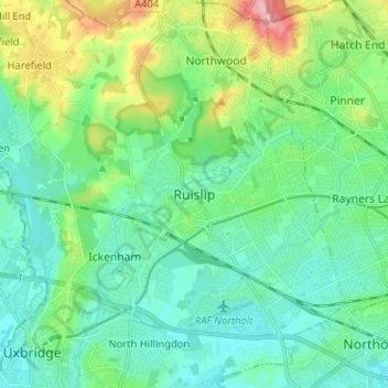
Navn: Topografisk kort Ruislip, højde, terræn.

Sted: Ruislip, Greater London, England, HA4 7TJ, United Kingdom (51.53756 -0.46785 51.61756 -0.38785)

Gennemsnitshøjde: 54 m

Minimum højde: 27 m

Maksimal højde: 137 m

Andre topografiske kort

Klik på et kort for at se dets topografi, dets højde og dets terræn.

Bristol

United Kingdom > England > City of Bristol

Gennemsnitshøjde: 55 m

Sheffield

United Kingdom > England

Sheffield nestles on the eastern foothills of the Pennines and is sculpted by a dramatic hill-and-valley system formed where five rivers — the Don, Sheaf, Rivelin, Loxley and Porter — converge, producing steep-sided valleys and gritstone ridgelines with much of the urban area built directly onto hillsides…

Gennemsnitshøjde: 168 m

Birmingham

United Kingdom > England

Birmingham is a snowy city relative to other large UK conurbations, due to its inland location and comparatively high elevation. Between 1961 and 1990 Birmingham Airport averaged 13.0 days of snow lying annually, compared to 5.33 at London Heathrow. Snow showers often pass through the city via the Cheshire gap…

Gennemsnitshøjde: 138 m

Greater London

United Kingdom > England

Gennemsnitshøjde: 66 m

South East England

United Kingdom > England

Near Weybridge are the UK headquarters of Sony with SSP Group (situated in Byfleet) and Procter & Gamble (next door to each other on The Heights Business Park near the former Brooklands racing circuit) with Kia Motors UK and Petroleum Geo-Services UK, and Gallaher Group (cigarettes) is to the north, next to…

Gennemsnitshøjde: 69 m

Norfolk

United Kingdom > England

Gennemsnitshøjde: 23 m

Leeds

United Kingdom > England

Gennemsnitshøjde: 96 m

Nottingham

United Kingdom > England > Nottinghamshire

Gennemsnitshøjde: 56 m

Greater Manchester

United Kingdom > England

Gennemsnitshøjde: 141 m

Suffolk

United Kingdom > England

The west of the county lies on more resistant Cretaceous chalk. This chalk is responsible for a sweeping tract of largely downland landscapes that stretches from Dorset in the south west to Dover in the south east and north through East Anglia to the Yorkshire Wolds. The chalk is less easily eroded so forms…

Gennemsnitshøjde: 35 m

Kent

United Kingdom > England

Kent was also the location of the largest number of art schools in the country during the nineteenth century, estimated by the art historian David Haste, to approach two hundred. This is believed to be the result of Kent being a front line county during the Napoleonic Wars. At this time, before the invention…

Gennemsnitshøjde: 37 m

Cambridge

United Kingdom > England > Cambridge

The city, like most of the UK, has a maritime climate highly influenced by the Gulf Stream. Located in the driest region of Britain, Cambridge's rainfall averages around 570 mm (22.44 in) per year, around half the national average, with some years occasionally falling into the semi-arid (under 500 mm (19.69…

Gennemsnitshøjde: 18 m

East of England

United Kingdom > England

The East of England region has the lowest elevation range in the UK. Twenty percent of the region is below mean sea level, most of this in North Cambridgeshire, Norfolk and on the Essex Coast. Most of the remaining area is of low elevation, with extensive glacial deposits. The Fens, a large area of reclaimed…

Gennemsnitshøjde: 39 m

Lake District National Park

United Kingdom > England

The Lake District is a roughly circular upland massif, deeply dissected by a broadly radial pattern of major valleys which are largely the result of repeated glaciations over the last 2 million years. The apparent radial pattern is not from a central dome, but from an axial watershed extending from St Bees…

Gennemsnitshøjde: 206 m

North East England

United Kingdom > England

North East England has a Marine west coast climate (generally found along the west coast of middle latitude continents) with narrower temperature ranges than the south of England and sufficient precipitation in all months. Summers and winters are mild rather than extremely hot or cold, due to the strong…

Gennemsnitshøjde: 165 m

Isle of Portland

United Kingdom > England > Dorset > Wyke Regis

In Museums Without Walls, Jonathan Meades declares that "Portland is a bulky chunk of geological, social, topographical and demographic weirdness. It is the obverse of a beauty spot. 'Beauty' in this construction implies the picturesque. Portland is gloriously bereft of this quality. It is awesome. There is…

Gennemsnitshøjde: 11 m

Cornwall

United Kingdom > England

The interior of the county consists of a roughly east–west spine of infertile and exposed upland, with a series of granite intrusions, such as Bodmin Moor, which contains the highest land within Cornwall. From east to west, and with approximately descending altitude, these are Bodmin Moor, Hensbarrow north…

Gennemsnitshøjde: 55 m

Liverpool

United Kingdom > England

Gennemsnitshøjde: 26 m

St. Agnes

United Kingdom > England > Cornwall > Mount Hawke

Gennemsnitshøjde: 78 m

Totnes

United Kingdom > England > Devon > South Hams

Gennemsnitshøjde: 66 m

Lincolnshire

United Kingdom > England

Gennemsnitshøjde: 28 m

Greater London

United Kingdom > England

London's topography is characterized by a gently rolling terrain shaped by the River Thames and its tributaries. The city lies within the London Basin, a natural depression bordered by higher grounds such as the North Downs to the south and the Chiltern Hills to the northwest. The Thames flows west to east,…

Gennemsnitshøjde: 66 m

Surrey

United Kingdom > England > Surrey

The highest elevation in Surrey is Leith Hill near Dorking. It is 295 m (968 ft) above sea level and is the second highest point in southeastern England after Walbury Hill in West Berkshire which is 297 m (974 ft).

Gennemsnitshøjde: 69 m

Fareham

United Kingdom > England > Fareham

Gennemsnitshøjde: 20 m

Warrington

United Kingdom > England

Gennemsnitshøjde: 32 m

Wigton

United Kingdom > England > Cumberland

Gennemsnitshøjde: 36 m

Sandwich

United Kingdom > England > Kent

Gennemsnitshøjde: 5 m

Borough of Wokingham

United Kingdom > England

Elevations range between 30 and 70 metres above sea level except higher in about 5% of the borough. The highest is an escarpment containing parts of the rural and wooded northern area, the hinterland of three Thames-side villages, facing the 30-mile long Chilterns AONB, west and north. A geological part of…

Gennemsnitshøjde: 66 m

Northamptonshire

United Kingdom > England

Gennemsnitshøjde: 97 m

East Sussex

United Kingdom > England

Gennemsnitshøjde: 43 m

Herefordshire

United Kingdom > England

Gennemsnitshøjde: 159 m

Somerset

United Kingdom > England

Gennemsnitshøjde: 87 m

Southampton

United Kingdom > England

Gennemsnitshøjde: 22 m

Borough of Luton

United Kingdom > England

The local climate around Luton is differentiated somewhat from much of South East England due to its position in the Chiltern Hills, meaning it tends to be 1–2 degrees Celsius cooler than the surrounding towns – often flights at Luton airport, lying 160 m (525 ft) above sea level, will be suspended when…

Gennemsnitshøjde: 146 m

South Petherton

United Kingdom > England > Somerset

Gennemsnitshøjde: 39 m

Wiltshire

United Kingdom > England

Gennemsnitshøjde: 115 m

Staffordshire

United Kingdom > England

Gennemsnitshøjde: 130 m

Wirral

United Kingdom > England

Gennemsnitshøjde: 21 m

Isle of Wight

United Kingdom > England

Gennemsnitshøjde: 17 m

Essex

United Kingdom > England

Gennemsnitshøjde: 44 m

Exeter

United Kingdom > England > Devon

The city of Exeter was established on the eastern bank of the River Exe on a ridge of land backed by a steep hill. It is at this point that the Exe, having just been joined by the River Creedy, opens onto a wide flood plain and estuary which results in quite common flooding. Historically this was the lowest…

Gennemsnitshøjde: 56 m

Barnsley

United Kingdom > England

Gennemsnitshøjde: 139 m

Milborne St. Andrew

United Kingdom > England > Dorset

Gennemsnitshøjde: 93 m

Battle

United Kingdom > England > East Sussex > Rother > Battle

Gennemsnitshøjde: 66 m

Yorkshire

United Kingdom > England

In Yorkshire there is a very close relationship between the major topographical areas and the geological period in which they were formed. The Pennine chain of hills in the west is of Carboniferous origin. The central vale is Permo-Triassic. The North York Moors in the north-east of the county are Jurassic in…

Gennemsnitshøjde: 130 m

Tak fordi du støtter denne side ❤️
Giv en donation

Gør dig klar til dit næste eventyr:

Som Amazon-partner tjener denne side en kommission på kvalificerede køb uden ekstra omkostninger for dig.

Todmorden

United Kingdom > England > Calderdale > Lydgate

Todmorden Town Hall, which was designed in the Neo-Classical style, dominates the centre of the town. The building straddles the Walsden Water, a tributary of the River Calder, and was situated in both Lancashire and Yorkshire until the administrative county boundary was moved on 1 January 1888. Designed by…

Gennemsnitshøjde: 311 m

Oxfordshire

United Kingdom > England

Gennemsnitshøjde: 113 m

Oxford

United Kingdom > England > Oxfordshire

Gennemsnitshøjde: 81 m

Great Dunmow

United Kingdom > England > Uttlesford

Gennemsnitshøjde: 81 m

Epping Forest

United Kingdom > England > Essex > Epping Forest > Debden Green

It lies on a ridge between the valleys of the rivers Lea and Roding. It contains areas of woodland, grassland, heath, streams, bogs and ponds, and its elevation and thin gravelly soil (the result of glaciation) historically made it less suitable for agriculture. The Forest was historically managed as a common;…

Gennemsnitshøjde: 44 m

Shalford

United Kingdom > England > Surrey > Guildford > Guildford

Lt.Col. Henry Haversham Godwin-Austen (1834–1923), topographer, geologist, naturalist and explorer who surveyed the Himalayan region, including K2, sometimes known as Mt. Godwin-Austen, for a time had an estate in Shalford.

Gennemsnitshøjde: 54 m

Watton

United Kingdom > England > Norfolk > Breckland District

Gennemsnitshøjde: 48 m

Burgess Hill

United Kingdom > England > West Sussex > Mid Sussex

Gennemsnitshøjde: 40 m

Harpenden

United Kingdom > England > Hertfordshire > St Albans

Gennemsnitshøjde: 119 m

Wollaton Park

United Kingdom > England > Nottingham > Wollaton

Gennemsnitshøjde: 44 m

Otley

United Kingdom > England > Leeds

Gennemsnitshøjde: 84 m

River

United Kingdom > England > Dover

Gennemsnitshøjde: 84 m

Rutland Water

United Kingdom > England > Rutland > Hambleton

Gennemsnitshøjde: 95 m

Richmond Park

United Kingdom > England > Greater London

Gennemsnitshøjde: 26 m

Leicestershire

United Kingdom > England

A large part of the north-west of the county, around Coalville, forms part of the new National Forest area extending into Derbyshire and Staffordshire. The highest point of the county is Bardon Hill at 278 m (912 ft), which is also a Marilyn; with other hilly/upland areas of around 150–200 metres (490–660…

Gennemsnitshøjde: 97 m

Cumbria

United Kingdom > England

Gennemsnitshøjde: 186 m

Petersfield

United Kingdom > England > Hampshire > East Hampshire > Sheet

Gennemsnitshøjde: 73 m

Chatham

United Kingdom > England > Medway

Gennemsnitshøjde: 70 m

Worcester

United Kingdom > England > Worcestershire

Gennemsnitshøjde: 38 m

Gloucester

United Kingdom > England > Gloucestershire

Gennemsnitshøjde: 36 m

Horsham

United Kingdom > England > West Sussex

Gennemsnitshøjde: 59 m

Chelmsford

United Kingdom > England > Essex

Gennemsnitshøjde: 54 m

East Anglia

United Kingdom > England

Gennemsnitshøjde: 29 m

Staffordshire

United Kingdom > England

Gennemsnitshøjde: 130 m

Crystal Palace Park

United Kingdom > England > London

Gennemsnitshøjde: 73 m

Sussex

United Kingdom > England

Gennemsnitshøjde: 39 m

Brighton and Hove

United Kingdom > England

Gennemsnitshøjde: 63 m

Derbyshire

United Kingdom > England

Due to its central location in England and altitude range from 27 metres in the south to 636 metres in the north, Derbyshire contains many species at the edge of their UK distribution ranges. Some species with a predominantly northern British distribution are at the southern limit of their range, whilst others…

Gennemsnitshøjde: 144 m

West Yorkshire

United Kingdom > England

Wakefield's Parish Church was raised to cathedral status in 1888 and after the elevation of Wakefield to diocese, Wakefield Council immediately sought city status and this was granted in July 1888. However the industrial revolution, which changed West and South Yorkshire significantly, led to the growth of…

Gennemsnitshøjde: 172 m

Merseyside

United Kingdom > England

Gennemsnitshøjde: 23 m

Central Bedfordshire

United Kingdom > England

Gennemsnitshøjde: 89 m

Hertfordshire

United Kingdom > England

Elevations are higher in the north and west, reaching more than 800 feet (240 m) in the Chilterns near Tring. The county centres on the headwaters and upper valleys of the rivers Lea and the Colne; both flow south, and each is accompanied by a canal. Hertfordshire's undeveloped land is mainly agricultural,…

Gennemsnitshøjde: 82 m

Bolton

United Kingdom > England

Gennemsnitshøjde: 151 m

Stockport

United Kingdom > England

Gennemsnitshøjde: 95 m

Manchester

United Kingdom > England

Gennemsnitshøjde: 66 m

Basingstoke

United Kingdom > England > Hampshire > Basingstoke and Deane

Situated in a valley through the Hampshire Downs at an average elevation of 88 metres (289 ft) Basingstoke is a major interchange between Reading, Newbury, Andover, Winchester, and Alton, and lies on the natural trade route between the southwest of England and London. The area had been something of an…

Gennemsnitshøjde: 109 m

Bath

United Kingdom > England > Bath and North East Somerset

Bath is in the Avon Valley and is surrounded by limestone hills as it is near the southern edge of the Cotswolds, a designated Area of Outstanding Natural Beauty, and the limestone Mendip Hills rise around 7 miles (11 km) south of the city. The hills that surround and make up the city have a maximum altitude…

Gennemsnitshøjde: 100 m

Lincoln

United Kingdom > England > Lincolnshire

Lincoln lies 157 mi (253 km) north of London, at an altitude of 67 ft (20.4 m) by the River Witham up to 246 ft (75.0 m) on Castle Hill. It fills a gap in the Lincoln Cliff escarpment, which runs north and south through central Lincolnshire, with altitudes up to 200 feet (61 metres). The city lies on the River…

Gennemsnitshøjde: 29 m

Norwich

United Kingdom > England > Norfolk

Gennemsnitshøjde: 28 m

Woodley

United Kingdom > England > Borough of Wokingham

Gennemsnitshøjde: 50 m

Slapton Sands

United Kingdom > England > Devon > South Hams > Torcross

Gennemsnitshøjde: 28 m

Chilterns National Landscape

United Kingdom > England > Buckinghamshire

The highest point is at 267 m (876 ft.) above sea level at Haddington Hill near Wendover in Buckinghamshire; a stone monument marks the summit. The nearby Ivinghoe Beacon is a more prominent hill, although its altitude is only 249 m (817 ft.). It is the starting point of the Icknield Way Path and the Ridgeway…

Gennemsnitshøjde: 102 m

Gør dig klar til dit næste eventyr:

Termos & kop - Holder drikke varme på turen
🏮Campinglanterne - Skab hygge og lys i lejren med en genopladelig lampe
📱Vandtæt mobilcover - Beskytter din smartphone mod vand, støv og stød
🧢Outdoor kasket - Solbeskyttelse til dine ture
👟Trail løbesko - Lette sko til løb i naturen

Som Amazon-partner tjener denne side en kommission på kvalificerede køb uden ekstra omkostninger for dig.