

Topografisk kort Arnold
Klik på kortet for at se højden.
Arnold
The local topography suggests that Arnold can never have been a haunt of eagles, because they inhabit areas of rocky outcrops, which have formed cliffs: the nearest such location is Creswell Crags, some 20 miles (32 km) north-west as the eagle flies. However, the fish-eating white-tailed eagle (also known as the erne) could have caught fish in the River Trent, which lies 4 miles (6.4 km) south-east of Arnold, on the other side of the Mapperley Plains ridge: these eagles might then have flown north-west in the evenings to roost in the ancient woodland area now known as Arnold. The Anglo-Saxon migrant-invaders, when they arrived along the River Trent from the Humber Estuary c. 500 A.D., might have seen these eagles—which measure 66–94 cm (26–37 in) in length with a 1.78–2.45 m (5.8–8.0 ft) wingspan—flying northwest in the evenings and named this roosting location 'Erne-Halh' or 'Erne-Haugh', meaning 'eagle's nook' or 'eagle's corner'.
Om dette kort
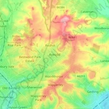
Navn: Topografisk kort Arnold, højde, terræn.
Gennemsnitshøjde: 81 m
Minimum højde: 20 m
Maksimal højde: 163 m
Andre topografiske kort
Klik på et kort for at se dets topografi, dets højde og dets terræn.


Gedling Country Park
United Kingdom > England > Nottinghamshire > Gedling > Carlton
Gennemsnitshøjde: 80 m


Lambley Lane Recreation Ground (North)
United Kingdom > England > Nottinghamshire > Gedling > Carlton
Gennemsnitshøjde: 73 m

Colwick Country Park
United Kingdom > England > Nottinghamshire > Gedling > Carlton > Colwick
Gennemsnitshøjde: 32 m
