
Giv en donation
Gør dig klar til dit næste eventyr:
Som Amazon-partner tjener denne side en kommission på kvalificerede køb uden ekstra omkostninger for dig.
Topografisk kort Nanjing
Klik på kortet for at se højden.
Giv en donation
Gør dig klar til dit næste eventyr:
Som Amazon-partner tjener denne side en kommission på kvalificerede køb uden ekstra omkostninger for dig.
Nanjing
There are mainly two types of soil in Nanjing: zonal soil and cultivated soil. The zonal soil is yellow-brown soil in the northern and central areas of Nanjing, and red soil in the southern part of the border with Anhui. The cultivated soil formed by man-made farming is mainly paddy soil, and there are some yellow Gang soil and vegetable garden soil. The distribution of soil presents a certain law with the undulation of topography and hydrological conditions, which can be divided into three categories: low mountain and hilly area, hilly area and plain area. According to the second national soil survey from 1980 to 1987, the soil in Nanjing is divided into 7 soil types, 13 subtypes, 30 soil genera and 66 soil species, with a total area of 416,300 hectares.
Giv en donation
Gør dig klar til dit næste eventyr:
Som Amazon-partner tjener denne side en kommission på kvalificerede køb uden ekstra omkostninger for dig.
Om dette kort
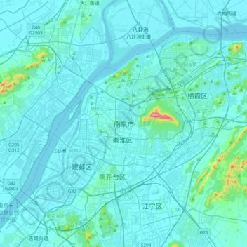
Navn: Topografisk kort Nanjing, højde, terræn.
Sted: Nanjing, Nanjing City, Jiangsu, 210005, China (31.88377 118.61887 32.20377 118.93887)
Gennemsnitshøjde: 25 m
Minimum højde: 0 m
Maksimal højde: 430 m
Giv en donation
Gør dig klar til dit næste eventyr:
Som Amazon-partner tjener denne side en kommission på kvalificerede køb uden ekstra omkostninger for dig.