
Topografisk kort Benhall Green
Klik på kortet for at se højden.
Om dette kort
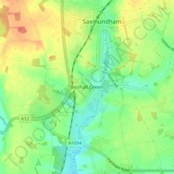
Navn: Topografisk kort Benhall Green, højde, terræn.
Gennemsnitshøjde: 21 m
Minimum højde: 1 m
Maksimal højde: 47 m
Andre topografiske kort
Klik på et kort for at se dets topografi, dets højde og dets terræn.
Woodbridge
United Kingdom > England > Suffolk > East Suffolk
The Suffolk Travler suggests a similar origin to The Dictionary but originating from a bridge over a hollow way that leads from Woodbridge Market Place to the Ipswich. But this is disputed by Rev. Thomas Carthew, then perpetual curate of Woodrbidge who points out that the bridge had existed for less than a…
Gennemsnitshøjde: 19 m
Gunton Sands
United Kingdom > England > Suffolk > East Suffolk > Lowestoft > Corton
Gennemsnitshøjde: 10 m
Little Bealings
United Kingdom > England > Suffolk > East Suffolk > Little Bealings
Gennemsnitshøjde: 24 m
Somerleyton, Ashby and Herringfleet
United Kingdom > England > Suffolk > East Suffolk > Somerleyton
Gennemsnitshøjde: 10 m
Sutton Hoo Archeological Site
United Kingdom > England > Suffolk > East Suffolk > Sutton
Gennemsnitshøjde: 19 m
Trimley St Martin
United Kingdom > England > Suffolk > East Suffolk
In 1741 the Suffolk Traveller John Kirby (topographer) surveyed the area around Felixstowe and in his note on Trimley he mentioned 'the lane to the pouch', which led to a small meadow east of the two churches, which contained a spring of clear water, generally regarded the source of Kingsfleet. The stream and…
Gennemsnitshøjde: 15 m
Lowestoft Inner Harbour
United Kingdom > England > Suffolk > East Suffolk > Lowestoft > Oulton Broad
Gennemsnitshøjde: 8 m