
Topografisk kort East Charleton
Klik på kortet for at se højden.
Om dette kort
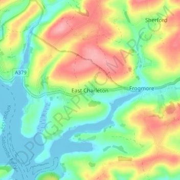
Navn: Topografisk kort East Charleton, højde, terræn.
Gennemsnitshøjde: 42 m
Minimum højde: -8 m
Maksimal højde: 105 m
Andre topografiske kort
Klik på et kort for at se dets topografi, dets højde og dets terræn.
Ivybridge
United Kingdom > England > Devon > South Hams
The topography of Ivybridge is generally hilly. This is because of the River Erme which flows right through the centre of town. To the east and to the west of the river the land is elevated forming a valley. The river first enters the town at 300 feet (91 m) above sea level and leaves the town at 130 feet (40…
Gennemsnitshøjde: 114 m
Blackpool Sands
United Kingdom > England > Devon > South Hams > Stoke Fleming > Blackpool
Gennemsnitshøjde: 54 m
Brent Hill Hifort
United Kingdom > England > Devon > South Hams > Didworthy > Shipley Bridge
Gennemsnitshøjde: 193 m