
Giv en donation
Gør dig klar til dit næste eventyr:
Som Amazon-partner tjener denne side en kommission på kvalificerede køb uden ekstra omkostninger for dig.
Topografisk kort Bentonville
Klik på kortet for at se højden.
Giv en donation
Gør dig klar til dit næste eventyr:
Som Amazon-partner tjener denne side en kommission på kvalificerede køb uden ekstra omkostninger for dig.
Bentonville
It lies along County Road 700N northwest of the city of Connersville, the county seat of Fayette County. Its elevation is 1,060 feet (323 m), and it is located at 39°44′43″N 85°11′39″W / 39.74528°N 85.19417°W / 39.74528; -85.19417 (39.7453242, -85.1941317).
Giv en donation
Gør dig klar til dit næste eventyr:
Som Amazon-partner tjener denne side en kommission på kvalificerede køb uden ekstra omkostninger for dig.
Om dette kort
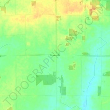
Navn: Topografisk kort Bentonville, højde, terræn.
Sted: Bentonville, Fayette County, Indiana, 47322, United States (39.72515 -85.26388 39.76515 -85.22388)
Gennemsnitshøjde: 323 m
Minimum højde: 306 m
Maksimal højde: 342 m
Giv en donation
Gør dig klar til dit næste eventyr:
Som Amazon-partner tjener denne side en kommission på kvalificerede køb uden ekstra omkostninger for dig.