
Topografisk kort Makassar
Klik på kortet for at se højden.
Makassar
Makassar City is a city located near the coast that stretches along the western and northern corridors and is also known as the "Waterfront City" which contains several rivers such as the Tallo River, Jeneberang River, and Pampang River) all of which flow into the city. Makassar City is a stretch of lowland at an altitude of between 0-25 meters above sea level.
Om dette kort
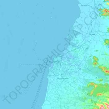
Navn: Topografisk kort Makassar, højde, terræn.
Sted: Makassar, South Sulawesi, Sulawesi, Indonesia (-5.23242 119.07382 -4.97503 119.54338)
Gennemsnitshøjde: 13 m
Minimum højde: -3 m
Maksimal højde: 525 m
Andre topografiske kort
Klik på et kort for at se dets topografi, dets højde og dets terræn.