
Topografisk kort Pipers Pool
Klik på kortet for at se højden.
Om dette kort
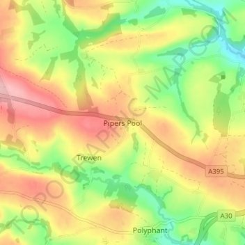
Navn: Topografisk kort Pipers Pool, højde, terræn.
Sted: Pipers Pool, Cornwall, England, PL15 8QR, United Kingdom (50.61066 -4.48399 50.65066 -4.44399)
Gennemsnitshøjde: 170 m
Minimum højde: 97 m
Maksimal højde: 243 m
Andre topografiske kort
Klik på et kort for at se dets topografi, dets højde og dets terræn.
St. Columb Major
United Kingdom > England > Cornwall
St Columb occupies a plateau at about 300 feet (91 m) elevation. The north part of the town (known as 'Bridge') descends into the Vale of Lanherne, having a minimum elevation of approximately 165 feet (50 m). It was originally a linear settlement built on the main road running north-east to south-west, but…
Gennemsnitshøjde: 110 m