
Giv en donation
Gør dig klar til dit næste eventyr:
Som Amazon-partner tjener denne side en kommission på kvalificerede køb uden ekstra omkostninger for dig.
Topografisk kort Kerguelen Archipelago
Klik på kortet for at se højden.
Giv en donation
Gør dig klar til dit næste eventyr:
Som Amazon-partner tjener denne side en kommission på kvalificerede køb uden ekstra omkostninger for dig.
Kerguelen Archipelago
The highest point is Mont Ross in the Gallieni Massif, which rises along the southern coast of the island and has an elevation of 1,850 metres (6,070 ft). The Cook Ice Cap (French: Calotte Glaciaire Cook), France's largest glacier with an area of about 403 km2 (156 sq mi), lies on the west-central part of the island. Overall, the glaciers of the Kerguelen Islands cover just over 500 km2 (190 sq mi). Grande Terre has also numerous bays, inlets, fjords, and coves, as well as several peninsulas and promontories. The most important ones are listed below.
Giv en donation
Gør dig klar til dit næste eventyr:
Som Amazon-partner tjener denne side en kommission på kvalificerede køb uden ekstra omkostninger for dig.
Om dette kort
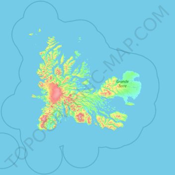
Navn: Topografisk kort Kerguelen Archipelago, højde, terræn.
Gennemsnitshøjde: 38 m
Minimum højde: -2 m
Maksimal højde: 1.451 m
Giv en donation
Gør dig klar til dit næste eventyr:
Som Amazon-partner tjener denne side en kommission på kvalificerede køb uden ekstra omkostninger for dig.
Andre topografiske kort
Klik på et kort for at se dets topografi, dets højde og dets terræn.