
Giv en donation
Gør dig klar til dit næste eventyr:
Som Amazon-partner tjener denne side en kommission på kvalificerede køb uden ekstra omkostninger for dig.
Topografisk kort Geronimo Estates
Klik på kortet for at se højden.
Giv en donation
Gør dig klar til dit næste eventyr:
Som Amazon-partner tjener denne side en kommission på kvalificerede køb uden ekstra omkostninger for dig.
Om dette kort
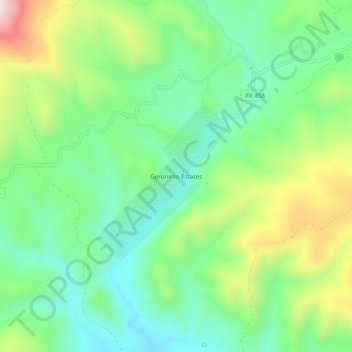
Navn: Topografisk kort Geronimo Estates, højde, terræn.
Sted: Geronimo Estates, Gila County, Arizona, United States (34.34698 -111.37875 34.38698 -111.33875)
Gennemsnitshøjde: 1.654 m
Minimum højde: 1.486 m
Maksimal højde: 1.985 m
Giv en donation
Gør dig klar til dit næste eventyr:
Som Amazon-partner tjener denne side en kommission på kvalificerede køb uden ekstra omkostninger for dig.
Andre topografiske kort
Klik på et kort for at se dets topografi, dets højde og dets terræn.
Giv en donation
Gør dig klar til dit næste eventyr:
Som Amazon-partner tjener denne side en kommission på kvalificerede køb uden ekstra omkostninger for dig.
Star Valley
United States > Arizona > Gila County
According to the United States Census Bureau, the town has a total area of 36.1 square miles (93.6 km2), of which 0.01 square miles (0.02 km2), or 0.03%, is water. Star Valley sits at an elevation of 4,650 feet (1,420 m) and takes its name from the valley in which it is located, formed by Houston Creek, which…
Gennemsnitshøjde: 1.509 m
Giv en donation
Gør dig klar til dit næste eventyr:
Som Amazon-partner tjener denne side en kommission på kvalificerede køb uden ekstra omkostninger for dig.