
Giv en donation
Gør dig klar til dit næste eventyr:
Som Amazon-partner tjener denne side en kommission på kvalificerede køb uden ekstra omkostninger for dig.
Topografisk kort Gunten
Klik på kortet for at se højden.
Giv en donation
Gør dig klar til dit næste eventyr:
Som Amazon-partner tjener denne side en kommission på kvalificerede køb uden ekstra omkostninger for dig.
Om dette kort
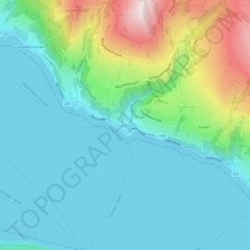
Navn: Topografisk kort Gunten, højde, terræn.
Gennemsnitshøjde: 694 m
Minimum højde: 548 m
Maksimal højde: 1.169 m
Giv en donation
Gør dig klar til dit næste eventyr:
Som Amazon-partner tjener denne side en kommission på kvalificerede køb uden ekstra omkostninger for dig.
Andre topografiske kort
Klik på et kort for at se dets topografi, dets højde og dets terræn.
Sigriswil
Switzerland > Bern > Thun administrative district
Archeological remains dating from the Late Neolithic and Bronze Age show that the area around Sigriswil has been inhabited as early as 5000 years ago. It's thought that the first modern inhabitants can be traced back to Alamanni tribesmen who settled on the banks of Thun lake around the 5th Century A.D., later…
Gennemsnitshøjde: 959 m
Thun
Switzerland > Bern > Thun administrative district
The center of Thun is located on the Aare, just downstream of the point where that river flows out of Lake Thun, and encompasses both banks of the river and an island between. The town covers an area of 21.6 km2 (8.3 sq mi), with the town boundaries reaching up to 4 km (2.5 mi) from the town centre. The town…
Gennemsnitshøjde: 637 m
Giv en donation
Gør dig klar til dit næste eventyr:
Som Amazon-partner tjener denne side en kommission på kvalificerede køb uden ekstra omkostninger for dig.