
Giv en donation
Gør dig klar til dit næste eventyr:
Som Amazon-partner tjener denne side en kommission på kvalificerede køb uden ekstra omkostninger for dig.
Topografisk kort Croft Castle
Klik på kortet for at se højden.
Giv en donation
Gør dig klar til dit næste eventyr:
Som Amazon-partner tjener denne side en kommission på kvalificerede køb uden ekstra omkostninger for dig.
Croft Castle
The present building dates from the 1660s during the time when Herbert Croft was Bishop of Hereford, replacing an earlier house some thirty yards to the west, which was excavated by Herefordshire County Archaeologist Prof. Keith Ray and volunteers in 2002. The manor house is a quadrangular stone structure around a central courtyard with round corner towers, and a square bay on the north elevation. Some stone mullion windows remain on all elevations. The castle is one of the first examples of medieval revival, and has affinities to Ruperra Castle, Caerphilly, and Lulworth Castle, Wareham, Dorset.
Giv en donation
Gør dig klar til dit næste eventyr:
Som Amazon-partner tjener denne side en kommission på kvalificerede køb uden ekstra omkostninger for dig.
Om dette kort
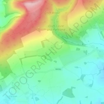
Navn: Topografisk kort Croft Castle, højde, terræn.
Gennemsnitshøjde: 173 m
Minimum højde: 99 m
Maksimal højde: 300 m
Giv en donation
Gør dig klar til dit næste eventyr:
Som Amazon-partner tjener denne side en kommission på kvalificerede køb uden ekstra omkostninger for dig.
Andre topografiske kort
Klik på et kort for at se dets topografi, dets højde og dets terræn.