
Topografisk kort Cropton
Klik på kortet for at se højden.
Om dette kort
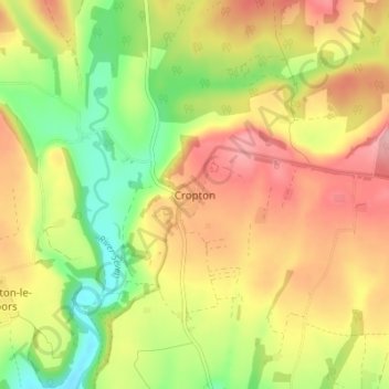
Navn: Topografisk kort Cropton, højde, terræn.
Gennemsnitshøjde: 119 m
Minimum højde: 47 m
Maksimal højde: 187 m
Andre topografiske kort
Klik på et kort for at se dets topografi, dets højde og dets terræn.
Farndale
United Kingdom > England > North Yorkshire > Ryedale > Gillamoor
With the population having decreased greatly from the 668 that is recorded in "A Topographical Dictionary of Yorkshire" by Thomas Lansdale published in 1822 when farndale East side had a population of 455 and Farndale West Side had a Population of 213.
Gennemsnitshøjde: 273 m
Willerby Brow Plantation
United Kingdom > England > North Yorkshire > Ryedale > Staxton > Binnington
Gennemsnitshøjde: 100 m