
Topografisk kort Rufforth
Klik på kortet for at se højden.
Om dette kort
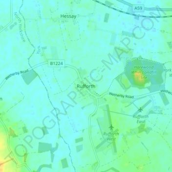
Navn: Topografisk kort Rufforth, højde, terræn.
Sted: Rufforth, York, England, YO23 3RG, United Kingdom (53.93730 -1.21726 53.97730 -1.17726)
Gennemsnitshøjde: 17 m
Minimum højde: 12 m
Maksimal højde: 34 m
Andre topografiske kort
Klik på et kort for at se dets topografi, dets højde og dets terræn.
Askham Bog Nature Reserve
United Kingdom > England > York > Askham Bryan
However, subsequent colonization by common reed, whose fossilized root fragments have been found immediately above the nekron mud layer, lead to a reduced extent of open water. In turn, a layer of fen peat gradually accumulated above the mud in the bog centre to begin forming a raised bog. The increased…
Gennemsnitshøjde: 16 m