
Giv en donation
Gør dig klar til dit næste eventyr:
Som Amazon-partner tjener denne side en kommission på kvalificerede køb uden ekstra omkostninger for dig.
Topografisk kort Steg
Klik på kortet for at se højden.
Giv en donation
Gør dig klar til dit næste eventyr:
Som Amazon-partner tjener denne side en kommission på kvalificerede køb uden ekstra omkostninger for dig.
Om dette kort
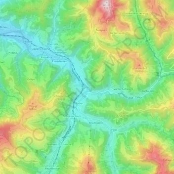
Navn: Topografisk kort Steg, højde, terræn.
Sted: Steg, Fischenthal, Bezirk Hinwil, Zurich, 8496, Switzerland (47.33141 8.91514 47.37141 8.95514)
Gennemsnitshøjde: 836 m
Minimum højde: 664 m
Maksimal højde: 1.122 m
Giv en donation
Gør dig klar til dit næste eventyr:
Som Amazon-partner tjener denne side en kommission på kvalificerede køb uden ekstra omkostninger for dig.
Andre topografiske kort
Klik på et kort for at se dets topografi, dets højde og dets terræn.
Wald (ZH)
Switzerland > Zurich > Bezirk Hinwil
At the turn of the 19th and 20th centuries, there were 16 factories in Wald, all of which made their money from textiles. At this time, Wald was also known as the "Manchester of the Canton of Zurich". In the 1860s, the Oberholzer family of factory owners promoted social welfare by establishing workers' housing…
Gennemsnitshøjde: 790 m
Giv en donation
Gør dig klar til dit næste eventyr:
Som Amazon-partner tjener denne side en kommission på kvalificerede køb uden ekstra omkostninger for dig.