
Topografisk kort High Willhays
Klik på kortet for at se højden.
High Willhays
High Willhays and Yes Tor are the only summits in England south of Kinder Scout in the Peak District to rise above 2,000 feet (610 m), apart from Black Mountain on the Welsh border. Before Ordnance Survey measured accurately the heights of High Willhays and Yes Tor many people believed Yes Tor was the higher of the two, and it was only the local farmers and moormen that believed the contrary. However, the first topographical survey of the area carried out by Ordnance Survey suggested that High Willhays was 12 feet (3.7 m) higher, although the difference has now been measured at just 8 feet (2.4 m). William Crossing stated that High Willhays was the highest point in England south of Ingleborough in the Yorkshire Dales, but since then surveys have shown that Kinder Scout is also higher (albeit less prominent).
Om dette kort
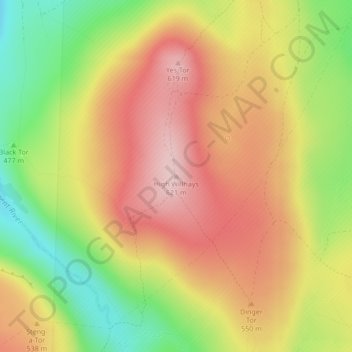
Navn: Topografisk kort High Willhays, højde, terræn.
Gennemsnitshøjde: 512 m
Minimum højde: 384 m
Maksimal højde: 616 m
Andre topografiske kort
Klik på et kort for at se dets topografi, dets højde og dets terræn.
Princetown
United Kingdom > England > Devon > West Devon
Princetown, like the rest of Dartmoor, experiences colder and wetter weather than most of Devon, especially because of its high altitude. Snow is uncommon but is usually heavy when it does fall. According to the Köppen climate classification the climate would be classified as Cfb bordering on Cfc.
Gennemsnitshøjde: 415 m
Burrator Reservoir
United Kingdom > England > Devon > West Devon > Meavy > Sheepstor
Gennemsnitshøjde: 255 m
Wistman's Wood (Nature Reserve)
United Kingdom > England > Devon > West Devon
Wistman's Wood is one of Britain's last remaining ancient temperate rainforests and one of three remote high-altitude oakwoods on Dartmoor in Devon, England. The first written document to mention Wistman's Wood dates to the 17th century, while more recent tree-ring studies show that individual trees could be…
Gennemsnitshøjde: 433 m