
Giv en donation
Gør dig klar til dit næste eventyr:
Som Amazon-partner tjener denne side en kommission på kvalificerede køb uden ekstra omkostninger for dig.
Topografisk kort Gunung Cemaru
Klik på kortet for at se højden.
Giv en donation
Gør dig klar til dit næste eventyr:
Som Amazon-partner tjener denne side en kommission på kvalificerede køb uden ekstra omkostninger for dig.
Om dette kort
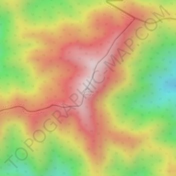
Navn: Topografisk kort Gunung Cemaru, højde, terræn.
Sted: Gunung Cemaru, East Kalimantan, Kalimantan, Indonesia (1.39958 114.19816 1.39968 114.19826)
Gennemsnitshøjde: 1.364 m
Minimum højde: 1.009 m
Maksimal højde: 1.617 m
Giv en donation
Gør dig klar til dit næste eventyr:
Som Amazon-partner tjener denne side en kommission på kvalificerede køb uden ekstra omkostninger for dig.
Andre topografiske kort
Klik på et kort for at se dets topografi, dets højde og dets terræn.
Giv en donation
Gør dig klar til dit næste eventyr:
Som Amazon-partner tjener denne side en kommission på kvalificerede køb uden ekstra omkostninger for dig.
Giv en donation
Gør dig klar til dit næste eventyr:
Som Amazon-partner tjener denne side en kommission på kvalificerede køb uden ekstra omkostninger for dig.
Giv en donation
Gør dig klar til dit næste eventyr:
Som Amazon-partner tjener denne side en kommission på kvalificerede køb uden ekstra omkostninger for dig.
Giv en donation
Gør dig klar til dit næste eventyr:
Som Amazon-partner tjener denne side en kommission på kvalificerede køb uden ekstra omkostninger for dig.
Giv en donation
Gør dig klar til dit næste eventyr:
Som Amazon-partner tjener denne side en kommission på kvalificerede køb uden ekstra omkostninger for dig.
Giv en donation
Gør dig klar til dit næste eventyr:
Som Amazon-partner tjener denne side en kommission på kvalificerede køb uden ekstra omkostninger for dig.
Balikpapan
Topography of Balikpapan is generally hilly (85%), with only small areas of flat land (15%), mostly along the coast and surrounding the hilly areas. The hills are less than 100 meters (330 feet) higher than the adjacent valleys. The altitude of Balikpapan ranges from 0 to 80 meters (260 feet) above sea level.…
Gennemsnitshøjde: 21 m
Giv en donation
Gør dig klar til dit næste eventyr:
Som Amazon-partner tjener denne side en kommission på kvalificerede køb uden ekstra omkostninger for dig.
Giv en donation
Gør dig klar til dit næste eventyr:
Som Amazon-partner tjener denne side en kommission på kvalificerede køb uden ekstra omkostninger for dig.
Giv en donation
Gør dig klar til dit næste eventyr:
Som Amazon-partner tjener denne side en kommission på kvalificerede køb uden ekstra omkostninger for dig.
Balikpapan
Topography of Balikpapan is generally hilly (85%), with only small areas of flat land (15%), mostly along the coast and surrounding the hilly areas. The hills are less than 100 meters (330 feet) higher than the adjacent valleys. The altitude of Balikpapan ranges from 0 to 80 meters (260 feet) above sea level.…
Gennemsnitshøjde: 21 m
Giv en donation
Gør dig klar til dit næste eventyr:
Som Amazon-partner tjener denne side en kommission på kvalificerede køb uden ekstra omkostninger for dig.
Balikpapan
Topography of Balikpapan is generally hilly (85%), with only small areas of flat land (15%), mostly along the coast and surrounding the hilly areas. The hills are less than 100 meters (330 feet) higher than the adjacent valleys. The altitude of Balikpapan ranges from 0 to 80 meters (260 feet) above sea level.…
Gennemsnitshøjde: 21 m
Giv en donation
Gør dig klar til dit næste eventyr:
Som Amazon-partner tjener denne side en kommission på kvalificerede køb uden ekstra omkostninger for dig.
Giv en donation
Gør dig klar til dit næste eventyr:
Som Amazon-partner tjener denne side en kommission på kvalificerede køb uden ekstra omkostninger for dig.