
Topografisk kort Over Peover
Klik på kortet for at se højden.
Om dette kort
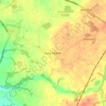
Navn: Topografisk kort Over Peover, højde, terræn.
Sted: Over Peover, Cheshire East, England, WA16 8TT, United Kingdom (53.24191 -2.34358 53.28191 -2.30358)
Gennemsnitshøjde: 70 m
Minimum højde: 44 m
Maksimal højde: 86 m
Andre topografiske kort
Klik på et kort for at se dets topografi, dets højde og dets terræn.
Alderley Edge
United Kingdom > England > Cheshire East
Alderley Edge is 6 miles (10 km) northwest of Macclesfield and 12 miles (19 km) south of Manchester, at the base of a steep and thickly wooded sandstone escarpment, Alderley Edge, which is the area's chief topographical feature and overlooks the Cheshire Plain.
Gennemsnitshøjde: 91 m
Peckforton Moss
United Kingdom > England > Cheshire East > Bulkeley > Peckforton
Gennemsnitshøjde: 100 m
Mottram St. Andrew
United Kingdom > England > Cheshire East > Mottram St Andrew
Gennemsnitshøjde: 105 m