
Topografisk kort Redhill
Klik på kortet for at se højden.
Redhill
To the north, the town joins with the village of Merstham, north of which there is a "wind gap" in the chalk hills of the North Downs, at an elevation of 120 metres (390 feet) above sea level, through which the A23 road heads in from London. Geologists have speculated that there may once have been a consequent-flowing river, flowing northwards from the centre of the Weald-Artois Anticline and towards the River Thames, which originally cut both the Redhill Gap in the Greensand Ridge and the Merstham Gap in the chalk hills of the North Downs, before its waters were caught by subsequent streams of the River Mole (which itself cuts gaps northwards through the ridge at Betchworth, and through the Downs at Dorking, on its way to the Thames). Today the whole Redhill area is part of the catchment area of the River Mole, and hence the Thames.
Om dette kort
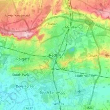
Navn: Topografisk kort Redhill, højde, terræn.
Gennemsnitshøjde: 107 m
Minimum højde: 47 m
Maksimal højde: 236 m
Andre topografiske kort
Klik på et kort for at se dets topografi, dets højde og dets terræn.
Lower Earlswood Lake
United Kingdom > England > Surrey > Reigate and Banstead > Redhill
Gennemsnitshøjde: 75 m
Redhill Common
United Kingdom > England > Surrey > Reigate and Banstead > Redhill
Gennemsnitshøjde: 92 m
Banstead Wood
United Kingdom > England > Surrey > Reigate and Banstead > Chipstead
Gennemsnitshøjde: 145 m
Reigate Park
United Kingdom > England > Surrey > Reigate and Banstead > Reigate
Gennemsnitshøjde: 80 m
Horley
United Kingdom > England > Surrey > Reigate and Banstead
Horley is at an altitude of around 54 m (177 ft) above mean sea level.
Gennemsnitshøjde: 58 m