Geolocate

Topografisk kort Brinscall

Klik på kortet for at se højden.

Om dette kort

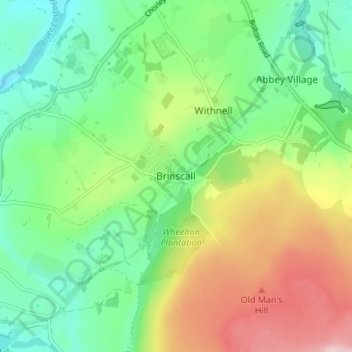
Navn: Topografisk kort Brinscall, højde, terræn.

Sted: Brinscall, Chorley, Lancashire, England, PR6 8QS, United Kingdom (53.66846 -2.58653 53.70846 -2.54653)

Gennemsnitshøjde: 195 m

Minimum højde: 103 m

Maksimal højde: 358 m

Andre topografiske kort

Klik på et kort for at se dets topografi, dets højde og dets terræn.

Whittle-le-Woods

United Kingdom > England > Lancashire > Chorley

Gennemsnitshøjde: 88 m

Rivington

United Kingdom > England > Lancashire > Chorley > Rivington

Gennemsnitshøjde: 244 m

Clayton-le-Woods

United Kingdom > England > Lancashire > Chorley

Gennemsnitshøjde: 72 m

Brindle

United Kingdom > England > Lancashire > Chorley > Brindle

Gennemsnitshøjde: 114 m

Heskin

United Kingdom > England > Lancashire > Chorley

Gennemsnitshøjde: 56 m

Euxton

United Kingdom > England > Lancashire > Chorley > Euxton

Gennemsnitshøjde: 50 m

Charnock Richard

United Kingdom > England > Lancashire > Chorley

Gennemsnitshøjde: 70 m

Adlington

United Kingdom > England > Lancashire > Chorley > Adlington

Gennemsnitshøjde: 95 m

Moss Wood

United Kingdom > England > Lancashire > Chorley

Gennemsnitshøjde: 8 m

Withnell

United Kingdom > England > Lancashire > Chorley > Abbey Village

Gennemsnitshøjde: 204 m

River Darwen

United Kingdom > England > Lancashire > Chorley

Gennemsnitshøjde: 123 m

Hoghton

United Kingdom > England > Lancashire > Chorley > Hoghton

Gennemsnitshøjde: 104 m

Croston

United Kingdom > England > Lancashire > Chorley

Gennemsnitshøjde: 8 m

Bretherton

United Kingdom > England > Lancashire > Chorley

Gennemsnitshøjde: 10 m

Heapey

United Kingdom > England > Lancashire > Chorley > Wheelton

Gennemsnitshøjde: 127 m

Wheelton

United Kingdom > England > Lancashire > Chorley

Gennemsnitshøjde: 183 m

Coppull

United Kingdom > England > Lancashire > Chorley

The settlement has an Anglo Saxon name describing its topography derived from the Old English copp a hill top and hyll a hill. The township was variously recorded as Cophull and Cophulle in 1277, Copphull in 1351, Copthull in 1374 and Coppull from 1444.

Gennemsnitshøjde: 82 m

Bretherton

United Kingdom > England > Lancashire > Chorley > Bretherton

Gennemsnitshøjde: 10 m

Coppull

United Kingdom > England > Lancashire > Chorley

The settlement has an Anglo Saxon name describing its topography derived from the Old English copp a hill top and hyll a hill. The township was variously recorded as Cophull and Cophulle in 1277, Copphull in 1351, Copthull in 1374 and Coppull from 1444.

Gennemsnitshøjde: 80 m

Gør dig klar til dit næste eventyr:

🍼Drikkedunk - Nem adgang til væske under cykling
Termokande - Hold din kaffe eller te varm hele dagen
🎒Vandrerygsæk - Ergonomiske rygsække til dagsture og længere ekspeditioner
🧴Myggerepellent - Beskyttelse mod insekter
🌧️Regnslag til cykling - Hold dig tør selv under kraftige byger

Som Amazon-partner tjener denne side en kommission på kvalificerede køb uden ekstra omkostninger for dig.