
Topografisk kort Fence
Klik på kortet for at se højden.
Om dette kort
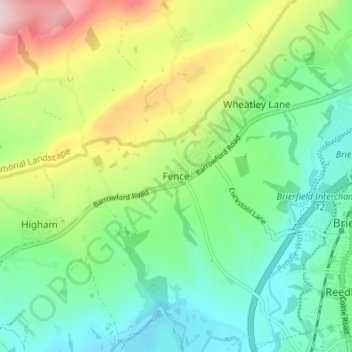
Navn: Topografisk kort Fence, højde, terræn.
Gennemsnitshøjde: 187 m
Minimum højde: 83 m
Maksimal højde: 404 m
Andre topografiske kort
Klik på et kort for at se dets topografi, dets højde og dets terræn.
Colne Water
United Kingdom > England > Lancashire > Borough of Pendle > Laneshaw Bridge
Gennemsnitshøjde: 202 m
Colne
United Kingdom > England > Lancashire > Borough of Pendle
Pendle Leisure Trust runs the Pendle Leisure Centre next to the railway station. The facility has two swimming pools, a fitness centre and gymnasium, sauna and sports hall. In summer 2013, the outdoor all-weather pitch was replaced by Urban Altitude. This outdoor aerial assault course is the first of its kind…
Gennemsnitshøjde: 197 m
Laneshaw Bridge
United Kingdom > England > Lancashire > Borough of Pendle > Laneshaw Bridge
Gennemsnitshøjde: 269 m
Barrowford
United Kingdom > England > Lancashire > Borough of Pendle > Barrowford
Gennemsnitshøjde: 161 m
Barnoldswick
United Kingdom > England > Lancashire > Borough of Pendle > Salterforth
Gennemsnitshøjde: 175 m
Colne
United Kingdom > England > Lancashire > Borough of Pendle
Pendle Leisure Trust runs the Pendle Leisure Centre next to the railway station. The facility has two swimming pools, a fitness centre and gymnasium, sauna and sports hall. In summer 2013, the outdoor all-weather pitch was replaced by Urban Altitude. This outdoor aerial assault course is the first of its kind…
Gennemsnitshøjde: 197 m
Barnoldswick
United Kingdom > England > Lancashire > Borough of Pendle > Salterforth
Gennemsnitshøjde: 175 m