
Topografisk kort Gunung Perigi
Klik på kortet for at se højden.
Om dette kort
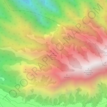
Navn: Topografisk kort Gunung Perigi, højde, terræn.
Gennemsnitshøjde: 1.336 m
Minimum højde: 755 m
Maksimal højde: 1.776 m
Andre topografiske kort
Klik på et kort for at se dets topografi, dets højde og dets terræn.
Lombok
Indonesia > West Nusa Tenggara
The island's topography is dominated by the centrally-located stratovolcano Mount Rinjani, the second-highest volcano in Indonesia, which rises to 3,726 metres (12,224 ft), making Lombok the 8th-highest island. The most recent eruption of Rinjani occurred in September 2016 at Gunung Barujari. In a 2010…
Gennemsnitshøjde: 192 m
Lombok
Indonesia > West Nusa Tenggara
The island's topography is dominated by the centrally located stratovolcano Mount Rinjani, the second-highest volcano in Indonesia, which rises to 3,726 metres (12,224 ft), making Lombok the 8th-highest island. The most recent eruption of Rinjani occurred in September 2016 at Gunung Barujari. In a 2010…
Gennemsnitshøjde: 192 m
Lombok
Indonesia > West Nusa Tenggara
The island's topography is dominated by the centrally-located stratovolcano Mount Rinjani, the second-highest volcano in Indonesia, which rises to 3,726 metres (12,224 ft), making Lombok the 8th-highest island. The most recent eruption of Rinjani occurred in September 2016 at Gunung Barujari. In a 2010…
Gennemsnitshøjde: 192 m
Lombok Tengah
Indonesia > West Nusa Tenggara
Central Lombok has a tropical climate with long dry seasons. The rain season normally commences in October and continues until April with an average rainfall of above 100mm during these months. In December falls have reached 382 mm. From May until September average rainfall is below 100 mm with the lowest…
Gennemsnitshøjde: 289 m
Lombok
Indonesia > West Nusa Tenggara
The island's topography is dominated by the centrally-located stratovolcano Mount Rinjani, the second-highest volcano in Indonesia, which rises to 3,726 metres (12,224 ft), making Lombok the 8th-highest island. The most recent eruption of Rinjani occurred in September 2016 at Gunung Barujari. In a 2010…
Gennemsnitshøjde: 192 m