
Giv en donation
Gør dig klar til dit næste eventyr:
Som Amazon-partner tjener denne side en kommission på kvalificerede køb uden ekstra omkostninger for dig.
Topografisk kort Winona
Klik på kortet for at se højden.
Giv en donation
Gør dig klar til dit næste eventyr:
Som Amazon-partner tjener denne side en kommission på kvalificerede køb uden ekstra omkostninger for dig.
Om dette kort
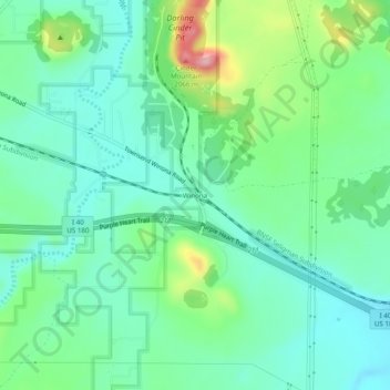
Navn: Topografisk kort Winona, højde, terræn.
Sted: Winona, Coconino County, Arizona, United States (35.18501 -111.42821 35.22501 -111.38821)
Gennemsnitshøjde: 1.920 m
Minimum højde: 1.869 m
Maksimal højde: 2.059 m
Giv en donation
Gør dig klar til dit næste eventyr:
Som Amazon-partner tjener denne side en kommission på kvalificerede køb uden ekstra omkostninger for dig.
Andre topografiske kort
Klik på et kort for at se dets topografi, dets højde og dets terræn.
Flagstaff
United States > Arizona > Coconino County
Flagstaff, located in Coconino County, Arizona, is characterized by its diverse topography, primarily shaped by its high elevation and volcanic activity. Sitting at around 7,000 feet (approximately 2,130 meters), the city is surrounded by the expansive Coconino National Forest, which features a blend of…
Gennemsnitshøjde: 2.176 m
Valle
United States > Arizona > Coconino County
Valle (Grand Canyon Junction) is a census-designated place in Coconino County, Arizona, United States. As of the 2010 US Census the population of Valle was 832. It lies at an altitude of 5,994 feet (1,827 m), at the junction of U.S. Route 180 and State Route 64. Its attractions include the Valle Airport (40G),…
Gennemsnitshøjde: 1.860 m
Upper Saginaw Reservoir
United States > Arizona > Coconino County > Williams City Limits
Gennemsnitshøjde: 2.149 m
Giv en donation
Gør dig klar til dit næste eventyr:
Som Amazon-partner tjener denne side en kommission på kvalificerede køb uden ekstra omkostninger for dig.
Giv en donation
Gør dig klar til dit næste eventyr:
Som Amazon-partner tjener denne side en kommission på kvalificerede køb uden ekstra omkostninger for dig.
Cameron
United States > Arizona > Coconino County
Cameron is located on the Navajo Nation. Elevation is 4,216 feet (1,285 m) above sea level. It is immediately south of the Little Colorado River, just above the beginning of the Little Colorado River Gorge and the stream's descent into the Grand Canyon. Cameron lies at the intersection of US 89 and State Route…
Gennemsnitshøjde: 1.331 m
Glen Canyon Dam
United States > Arizona > Coconino County
The Bureau of Reclamation favored the Echo Park site over Glen Canyon, because its narrow canyons and high elevation (more than 5,000 feet (1,500 m), as compared to 3,700 feet (1,100 m) at Glen Canyon) would lead to less evaporation. It said that building Echo Park Dam and a "low" Glen Canyon Dam would save…
Gennemsnitshøjde: 1.171 m
Giv en donation
Gør dig klar til dit næste eventyr:
Som Amazon-partner tjener denne side en kommission på kvalificerede køb uden ekstra omkostninger for dig.
Supai
United States > Arizona > Coconino County > Supai
Supai can be reached by hiking 8 miles (13 km), descending 2,004 feet (611 m) in elevation from Hualapai Hilltop through the Hualapai Canyon. Alternatively, the AirWest Helicopters service schedules flights from Hualapai Hilltop to Supai. Hualapai Hilltop is located about 70 miles (110 km) from the community…
Gennemsnitshøjde: 1.263 m
Giv en donation
Gør dig klar til dit næste eventyr:
Som Amazon-partner tjener denne side en kommission på kvalificerede køb uden ekstra omkostninger for dig.
Giv en donation
Gør dig klar til dit næste eventyr:
Som Amazon-partner tjener denne side en kommission på kvalificerede køb uden ekstra omkostninger for dig.
Giv en donation
Gør dig klar til dit næste eventyr:
Som Amazon-partner tjener denne side en kommission på kvalificerede køb uden ekstra omkostninger for dig.
Giv en donation
Gør dig klar til dit næste eventyr:
Som Amazon-partner tjener denne side en kommission på kvalificerede køb uden ekstra omkostninger for dig.