
Topografisk kort Wincanton
Klik på kortet for at se højden.
Om dette kort
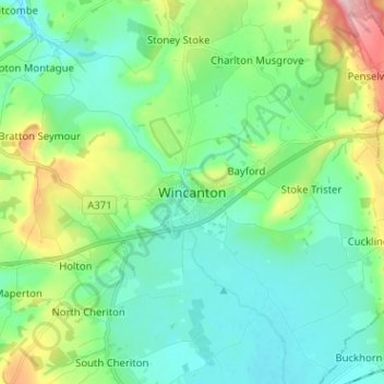
Navn: Topografisk kort Wincanton, højde, terræn.
Sted: Wincanton, Somerset, England, BA9 9LD, United Kingdom (51.01604 -2.45123 51.09604 -2.37123)
Gennemsnitshøjde: 102 m
Minimum højde: 55 m
Maksimal højde: 245 m
Andre topografiske kort
Klik på et kort for at se dets topografi, dets højde og dets terræn.
Priddy
United Kingdom > England > Somerset
The village lies in a small hollow near the summit of the Mendip range of hills, at an elevation of nearly 1,000 feet (300 m) above sea-level, and has evidence of occupation since neolithic times. There are remains of lead mining activities and caves in the limestone beneath the village.
Gennemsnitshøjde: 206 m
Small Brook
United Kingdom > England > Somerset > South Somerset > Haselbury Plucknett
Gennemsnitshøjde: 48 m
Quantock Hills National Landscape
United Kingdom > England > Somerset > Over Stowey
Gennemsnitshøjde: 116 m
Mells Park
United Kingdom > England > Somerset > Vobster
The architect Edwin Lutyens had known the Horners, and Mells Park, since 1896. In 1918 he unsuccessfully tried to persuade the Horners to rebuild Park House. However, Reginald McKenna, the chairman of Midland Bank, and formerly Home Secretary and Chancellor of the Exchequer under Asquith, was married to Pamela…
Gennemsnitshøjde: 134 m