
Giv en donation
Gør dig klar til dit næste eventyr:
Som Amazon-partner tjener denne side en kommission på kvalificerede køb uden ekstra omkostninger for dig.
Topografisk kort Pinetop-Lakeside
Klik på kortet for at se højden.
Giv en donation
Gør dig klar til dit næste eventyr:
Som Amazon-partner tjener denne side en kommission på kvalificerede køb uden ekstra omkostninger for dig.
Pinetop-Lakeside
Pinetop-Lakeside is nestled in the stunning White Mountains of northeastern Arizona, characterized by a varied topography that significantly influences its natural beauty and recreational opportunities. The terrain features elevations averaging around 6,795 feet, with rugged mountain landscapes interspersed with lush pine forests, rolling hills, and open meadows. This mountainous region is part of the Apache-Sitgreaves National Forest, providing a picturesque backdrop of tall coniferous trees and scenic views. Numerous lakes and streams, including Scott Reservoir and the nearby Pinedale Lake, are interspersed throughout the area, enhancing the rich biodiversity and offering a plethora of outdoor activities such as hiking, fishing, and skiing during the winter months. The area's elevation and topographical variations create distinct microclimates, making it a unique spot for both seasonal visitors and residents alike.
Giv en donation
Gør dig klar til dit næste eventyr:
Som Amazon-partner tjener denne side en kommission på kvalificerede køb uden ekstra omkostninger for dig.
Om dette kort
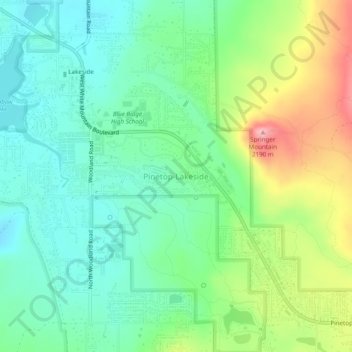
Navn: Topografisk kort Pinetop-Lakeside, højde, terræn.
Gennemsnitshøjde: 2.087 m
Minimum højde: 2.035 m
Maksimal højde: 2.196 m
Giv en donation
Gør dig klar til dit næste eventyr:
Som Amazon-partner tjener denne side en kommission på kvalificerede køb uden ekstra omkostninger for dig.
Andre topografiske kort
Klik på et kort for at se dets topografi, dets højde og dets terræn.
Monument Valley
United States > Arizona > Navajo County
The area is part of the Colorado Plateau. The elevation of the valley floor ranges from 5,000 to 6,000 feet (1,500 to 1,800 m) above sea level. The floor is largely siltstone of the Cutler Group, or sand derived from it, deposited by the meandering rivers that carved the valley. The valley's vivid red color…
Gennemsnitshøjde: 1.650 m
Giv en donation
Gør dig klar til dit næste eventyr:
Som Amazon-partner tjener denne side en kommission på kvalificerede køb uden ekstra omkostninger for dig.
Kayenta
United States > Arizona > Navajo County
Kayenta is located at 36°42′43″N 110°15′00″W / 36.71194°N 110.25000°W / 36.71194; -110.25000 (36.7118, -110.2505), at an elevation of 5,700 feet, (1,738 m).
Gennemsnitshøjde: 1.743 m
Three Sisters
United States > Arizona > Navajo County
The area is part of the Colorado Plateau. The elevation of the valley floor ranges from 5,000 to 6,000 feet (1,500 to 1,800 m) above sea level. The floor is largely siltstone of the Cutler Group, or sand derived from it, deposited by the meandering rivers that carved the valley. The valley's vivid red color…
Gennemsnitshøjde: 1.664 m
Lake of the Woods
United States > Arizona > Navajo County > Lake of the Woods
Gennemsnitshøjde: 2.037 m
Black Canyon Lake
United States > Arizona > Navajo County
The lake is located 18 miles (29 km) southwest of Heber in the Apache-Sitgreaves National Forests at an elevation of 7,060 feet (2,150 m). Access is restricted in the winter when roads are closed due to snow, generally December to early April.
Gennemsnitshøjde: 2.188 m
Giv en donation
Gør dig klar til dit næste eventyr:
Som Amazon-partner tjener denne side en kommission på kvalificerede køb uden ekstra omkostninger for dig.
Giv en donation
Gør dig klar til dit næste eventyr:
Som Amazon-partner tjener denne side en kommission på kvalificerede køb uden ekstra omkostninger for dig.