
Topografisk kort Canons Ashby
Klik på kortet for at se højden.
Om dette kort
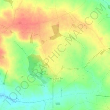
Navn: Topografisk kort Canons Ashby, højde, terræn.
Sted: Canons Ashby, West Northamptonshire, England, United Kingdom (52.14312 -1.18949 52.17081 -1.13722)
Gennemsnitshøjde: 159 m
Minimum højde: 127 m
Maksimal højde: 189 m
Andre topografiske kort
Klik på et kort for at se dets topografi, dets højde og dets terræn.
Lower Thorpe
United Kingdom > England > West Northamptonshire > Thorpe Mandeville
Gennemsnitshøjde: 154 m
Ravensthorpe Reservoir
United Kingdom > England > West Northamptonshire > Coton
Gennemsnitshøjde: 131 m