

Topografisk kort Waru
Klik på kortet for at se højden.
Om dette kort
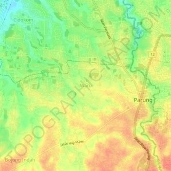
Navn: Topografisk kort Waru, højde, terræn.
Sted: Waru, Parung, Bogor, West Java, Java, 16330, Indonesia (-6.43796 106.69985 -6.39796 106.73985)
Gennemsnitshøjde: 93 m
Minimum højde: 65 m
Maksimal højde: 112 m
Andre topografiske kort
Klik på et kort for at se dets topografi, dets højde og dets terræn.


Cisarua
The district is known for its mild climate, tea fields, and extensive views, being located at a rather high altitude. Near the district is a mountain pass known for its villas and hostels, as well as a well-known "heritage" hotel known as the "Puncak Pass", built in 1928.
Gennemsnitshøjde: 1.270 m


Megamendung
Much of the district lies at an elevation of 500-600 metres, which moderates the temperature, and causing contrast to the heat of Greater Jakarta and other adjacent low-lying lands. Though much of the built-up area is not necessarily on rugged terrain, uneven ground is the most common terrain as it stands…
Gennemsnitshøjde: 738 m





Megamendung
Much of the district lies in an elevation of 500-600 metres, which moderates the temperature, and causing contrast to the heat of Greater Jakarta and other adjacent low-lying lands. Though much of the built-up area is not necessarily on rugged terrain, uneven ground is the most common terrain as it stands…
Gennemsnitshøjde: 742 m


Cisarua
Cisarua is a location and district in the Bogor Regency, located in the province of West Java, with a population of 127,096 in 2020. The district is known for its mild climate, tea fields, and extensive views, being located in a rather high altitude.
Gennemsnitshøjde: 1.310 m
