
Giv en donation
Gør dig klar til dit næste eventyr:
Som Amazon-partner tjener denne side en kommission på kvalificerede køb uden ekstra omkostninger for dig.
Topografisk kort Mount Graham
Klik på kortet for at se højden.
Giv en donation
Gør dig klar til dit næste eventyr:
Som Amazon-partner tjener denne side en kommission på kvalificerede køb uden ekstra omkostninger for dig.
Om dette kort
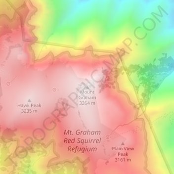
Navn: Topografisk kort Mount Graham, højde, terræn.
Sted: Mount Graham, Graham County, Arizona, United States (32.70159 -109.87144 32.70169 -109.87134)
Gennemsnitshøjde: 2.957 m
Minimum højde: 2.446 m
Maksimal højde: 3.260 m
Giv en donation
Gør dig klar til dit næste eventyr:
Som Amazon-partner tjener denne side en kommission på kvalificerede køb uden ekstra omkostninger for dig.
Andre topografiske kort
Klik på et kort for at se dets topografi, dets højde og dets terræn.
Swift Trail Junction
United States > Arizona > Graham County
Swift Trail Junction is a census-designated place (CDP) in Graham County, Arizona, United States. The population was 2,935 at the 2010 census, up from 2,195 in 2000. It is part of the Safford Micropolitan Statistical Area. It is situated at the junction of U.S. Route 191 and State Route 366 (also known as the…
Gennemsnitshøjde: 984 m