
Topografisk kort West Point
Klik på kortet for at se højden.
Om dette kort
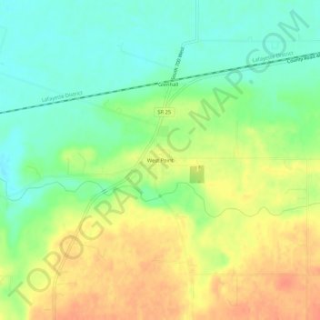
Navn: Topografisk kort West Point, højde, terræn.
Sted: West Point, Tippecanoe County, Indiana, 47992, United States (40.32468 -87.06218 40.36468 -87.02218)
Gennemsnitshøjde: 198 m
Minimum højde: 176 m
Maksimal højde: 222 m
Andre topografiske kort
Klik på et kort for at se dets topografi, dets højde og dets terræn.
Dayton
United States > Indiana > Tippecanoe County
Dayton is located in northwest Sheffield Township, at an elevation of 676 feet (206 m).
Gennemsnitshøjde: 203 m
Battle Ground
United States > Indiana > Tippecanoe County
Battle Ground is located at 40°30′36″N 86°50′18″W / 40.51000°N 86.83833°W / 40.51000; -86.83833 (40.510110, −86.838220) in Tippecanoe Township, one and a quarter miles northwest of the Wabash River. Its elevation is approximately 585 feet. The small Harrison Creek begins near Battle…
Gennemsnitshøjde: 180 m