
Giv en donation
Gør dig klar til dit næste eventyr:
Som Amazon-partner tjener denne side en kommission på kvalificerede køb uden ekstra omkostninger for dig.
Topografisk kort Rheinquelle
Klik på kortet for at se højden.
Giv en donation
Gør dig klar til dit næste eventyr:
Som Amazon-partner tjener denne side en kommission på kvalificerede køb uden ekstra omkostninger for dig.
Rheinquelle
The Swiss Federal Office of Topography and ETH Zürich indicate a point north of Lake Toma and the Rein da Tuma as the source of the Rhine (and also of the Vorderrhein), and as the source of the Hinterrhein a point in the upper valley of the Rheinwald, east of the Rheinwaldhorn.
Giv en donation
Gør dig klar til dit næste eventyr:
Som Amazon-partner tjener denne side en kommission på kvalificerede køb uden ekstra omkostninger for dig.
Om dette kort
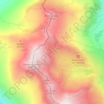
Navn: Topografisk kort Rheinquelle, højde, terræn.
Gennemsnitshøjde: 2.435 m
Minimum højde: 1.822 m
Maksimal højde: 2.832 m
Giv en donation
Gør dig klar til dit næste eventyr:
Som Amazon-partner tjener denne side en kommission på kvalificerede køb uden ekstra omkostninger for dig.
Andre topografiske kort
Klik på et kort for at se dets topografi, dets højde og dets terræn.