
Topografisk kort Newton
Klik på kortet for at se højden.
Om dette kort
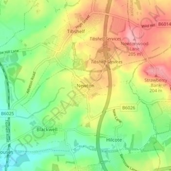
Navn: Topografisk kort Newton, højde, terræn.
Gennemsnitshøjde: 143 m
Minimum højde: 89 m
Maksimal højde: 210 m
Andre topografiske kort
Klik på et kort for at se dets topografi, dets højde og dets terræn.
Glapwell
United Kingdom > England > Derbyshire > Bolsover
Glapwell is a rural village and civil parish on the A617 road in the Bolsover District of north-east Derbyshire, The village is at the top of a steep hill at an elevation of 176m, on the western edge of the Southern Magnesian Limestone] overlooking the valley of the River Doe Lea (formerly known as the…
Gennemsnitshøjde: 156 m