
Giv en donation
Gør dig klar til dit næste eventyr:
Som Amazon-partner tjener denne side en kommission på kvalificerede køb uden ekstra omkostninger for dig.
Topografisk kort Buckshot
Klik på kortet for at se højden.
Giv en donation
Gør dig klar til dit næste eventyr:
Som Amazon-partner tjener denne side en kommission på kvalificerede køb uden ekstra omkostninger for dig.
Om dette kort
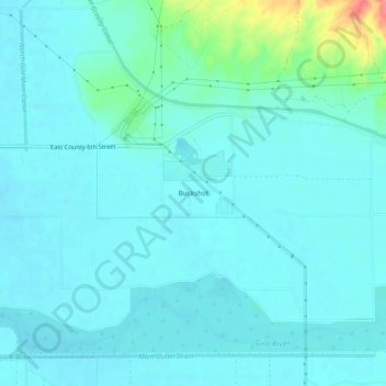
Navn: Topografisk kort Buckshot, højde, terræn.
Sted: Buckshot, Yuma County, Arizona, United States (32.71809 -114.50372 32.75809 -114.46372)
Gennemsnitshøjde: 52 m
Minimum højde: 41 m
Maksimal højde: 114 m
Giv en donation
Gør dig klar til dit næste eventyr:
Som Amazon-partner tjener denne side en kommission på kvalificerede køb uden ekstra omkostninger for dig.
Andre topografiske kort
Klik på et kort for at se dets topografi, dets højde og dets terræn.
Giv en donation
Gør dig klar til dit næste eventyr:
Som Amazon-partner tjener denne side en kommission på kvalificerede køb uden ekstra omkostninger for dig.
Giv en donation
Gør dig klar til dit næste eventyr:
Som Amazon-partner tjener denne side en kommission på kvalificerede køb uden ekstra omkostninger for dig.
Yuma Territorial Prison State Historic Park
United States > Arizona > Yuma County > Yuma
Gennemsnitshøjde: 43 m
Giv en donation
Gør dig klar til dit næste eventyr:
Som Amazon-partner tjener denne side en kommission på kvalificerede køb uden ekstra omkostninger for dig.