
Giv en donation
Gør dig klar til dit næste eventyr:
Som Amazon-partner tjener denne side en kommission på kvalificerede køb uden ekstra omkostninger for dig.
Topografisk kort Charles Mound
Klik på kortet for at se højden.
Giv en donation
Gør dig klar til dit næste eventyr:
Som Amazon-partner tjener denne side en kommission på kvalificerede køb uden ekstra omkostninger for dig.
Om dette kort
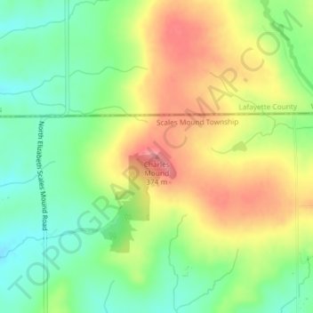
Navn: Topografisk kort Charles Mound, højde, terræn.
Gennemsnitshøjde: 326 m
Minimum højde: 285 m
Maksimal højde: 373 m
Giv en donation
Gør dig klar til dit næste eventyr:
Som Amazon-partner tjener denne side en kommission på kvalificerede køb uden ekstra omkostninger for dig.
Andre topografiske kort
Klik på et kort for at se dets topografi, dets højde og dets terræn.
Giv en donation
Gør dig klar til dit næste eventyr:
Som Amazon-partner tjener denne side en kommission på kvalificerede køb uden ekstra omkostninger for dig.
Stockton
United States > Illinois > Jo Daviess County
The village water tower sits on a ridge at elevation 1,105 ft (337 m) that rises to 1,120 ft (340 m) to the west at the village limits. To the northwest the same ridge line continues where U.S. Route 20 crests at 1,077 ft (328 m) just to the west. This ridge line continues for 3 miles to the northwest to…
Gennemsnitshøjde: 301 m
Giv en donation
Gør dig klar til dit næste eventyr:
Som Amazon-partner tjener denne side en kommission på kvalificerede køb uden ekstra omkostninger for dig.
Scales Mound
United States > Illinois > Jo Daviess County
Scales Mound is located in a region of the U.S. Midwest known as the Driftless Area, so called because it escaped glaciation during the last ice age. It covers parts of Illinois, Wisconsin, Minnesota and Iowa. The Illinois section is mostly limited to Jo Daviess County and small parts of Whiteside and Carroll…
Gennemsnitshøjde: 294 m