
Topografisk kort Crowden Tower
Klik på kortet for at se højden.
Om dette kort
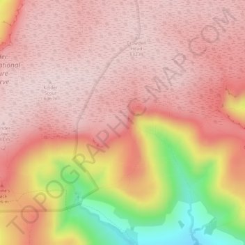
Navn: Topografisk kort Crowden Tower, højde, terræn.
Gennemsnitshøjde: 543 m
Minimum højde: 294 m
Maksimal højde: 638 m
Andre topografiske kort
Klik på et kort for at se dets topografi, dets højde og dets terræn.
New Mills
United Kingdom > England > Derbyshire > High Peak > Hague Bar
High Peak Borough Council have produced a Conservation Area Character Appraisal document, outlining the reasons that the Conservation Area has been designated as such. In justifying the reasons for designation, this document states of the town: "New Mills is a town of dramatic topography and origins that date…
Gennemsnitshøjde: 251 m
Crowden Great Brook
United Kingdom > England > Derbyshire > High Peak > Tintwistle > Crowden
Gennemsnitshøjde: 314 m
Buxton
United Kingdom > England > Derbyshire > High Peak
Buxton has an oceanic climate with short, mild summers and long, cool winters. At about 1,000 feet (300 m) above sea level, As the highest market town in England, Buxton's elevation makes it cooler and wetter than surrounding towns, with a daytime temperature typically about 2 °C lower than Manchester.
Gennemsnitshøjde: 334 m
Chapel-en-le-Frith
United Kingdom > England > Derbyshire > High Peak
In the rolling hills between Combs and Chapel is Bank Hall, extensively altered in 1872–74 for Henry Renshaw of Manchester on an ornate aerial plan with an elaborate stone balcony over the door, a bay window with fine botanical painted glass and canvas panels to the doors, formerly with painted panels by…
Gennemsnitshøjde: 324 m
Kinder Scout National Nature Reserve
United Kingdom > England > Derbyshire > High Peak > Hayfield
Gennemsnitshøjde: 513 m
Chisworth
United Kingdom > England > Derbyshire > High Peak > Higher Chisworth
Gennemsnitshøjde: 218 m
Derwent
United Kingdom > England > Derbyshire > High Peak > Bamford > Yorkshire Bridge
Gennemsnitshøjde: 287 m
Crowden Great Brook
United Kingdom > England > Derbyshire > High Peak > Tintwistle
Gennemsnitshøjde: 459 m
Bamford Edge
United Kingdom > England > Derbyshire > High Peak > Bamford > Yorkshire Bridge
Gennemsnitshøjde: 288 m
Shireowlers South Plantation
United Kingdom > England > Derbyshire > High Peak
Gennemsnitshøjde: 342 m
Buxton
United Kingdom > England > Derbyshire > High Peak
Buxton has an oceanic climate with short, mild summers and long, cool winters. At about 1,000 feet (300 m) above sea level, Buxton is the highest market town in England. Buxton's elevation makes it cooler and wetter than surrounding towns, with a daytime temperature typically about 2 °C lower than Manchester.
Gennemsnitshøjde: 334 m
Derwent
United Kingdom > England > Derbyshire > High Peak > Bamford > Yorkshire Bridge
Gennemsnitshøjde: 291 m
Chapel-en-le-Frith
United Kingdom > England > Derbyshire > High Peak
In the rolling hills between Combs and Chapel is Bank Hall, extensively altered in 1872–74 for Henry Renshaw of Manchester on an ornate aerial plan with an elaborate stone balcony over the door, a bay window with fine botanical painted glass and canvas panels to the doors, formerly with painted panels by…
Gennemsnitshøjde: 324 m
Derwent
United Kingdom > England > Derbyshire > High Peak > Bamford > Yorkshire Bridge
Gennemsnitshøjde: 293 m
New Mills
United Kingdom > England > Derbyshire > High Peak > Hague Bar
High Peak Borough Council have produced a Conservation Area Character Appraisal document, outlining the reasons that the Conservation Area has been designated as such. In justifying the reasons for designation, this document states of the town: "New Mills is a town of dramatic topography and origins that date…
Gennemsnitshøjde: 251 m
New Mills
United Kingdom > England > Derbyshire > High Peak
High Peak Borough Council have produced a Conservation Area Character Appraisal document, outlining the reasons that the Conservation Area has been designated as such. In justifying the reasons for designation, this document states of the town: "New Mills is a town of dramatic topography and origins that date…
Gennemsnitshøjde: 229 m
Buxton
United Kingdom > England > Derbyshire > High Peak
Buxton has an oceanic climate with short, mild summers and long, cool winters. At about 1,000 feet (300 m) above sea level, Buxton is the highest market town in England. Buxton's elevation makes it cooler and wetter than surrounding towns, with a daytime temperature typically about 2 °C lower than Manchester.
Gennemsnitshøjde: 334 m