
Giv en donation
Gør dig klar til dit næste eventyr:
Som Amazon-partner tjener denne side en kommission på kvalificerede køb uden ekstra omkostninger for dig.
Topografisk kort Madonnaville
Klik på kortet for at se højden.
Giv en donation
Gør dig klar til dit næste eventyr:
Som Amazon-partner tjener denne side en kommission på kvalificerede køb uden ekstra omkostninger for dig.
Om dette kort
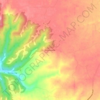
Navn: Topografisk kort Madonnaville, højde, terræn.
Sted: Madonnaville, Monroe County, Illinois, 62256, United States (38.24505 -90.26678 38.28505 -90.22678)
Gennemsnitshøjde: 207 m
Minimum højde: 133 m
Maksimal højde: 241 m
Giv en donation
Gør dig klar til dit næste eventyr:
Som Amazon-partner tjener denne side en kommission på kvalificerede køb uden ekstra omkostninger for dig.
Andre topografiske kort
Klik på et kort for at se dets topografi, dets højde og dets terræn.
Waterloo
United States > Illinois > Monroe County
Waterloo's history dates back to the 18th century, with the French being the first Europeans to settle in the area. The site was ideal because of its elevation; the proximity of the Mississippi River Valley brought frequent flooding to the lowlands. It was also close to Fort de Chartres, a French stronghold.…
Gennemsnitshøjde: 186 m
Giv en donation
Gør dig klar til dit næste eventyr:
Som Amazon-partner tjener denne side en kommission på kvalificerede køb uden ekstra omkostninger for dig.