
Topografisk kort Brasília
Klik på kortet for at se højden.
Brasília
The city sits at an elevation of 1,000 metres (3,300 ft) and more, high on the Brazilian Highlands in the country's center-western region. Paranoá Lake, a large artificial lake, was built to increase the amount of water available and to maintain the region's humidity. It has a marina, and hosts wakeboarders and windsurfers. Diving can also be practiced and one of the main attractions is Vila Amaury, an old village submerged in the lake. This is where the first construction workers of Brasilia used to live.
Om dette kort
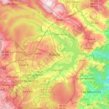
Navn: Topografisk kort Brasília, højde, terræn.
Gennemsnitshøjde: 1.084 m
Minimum højde: 865 m
Maksimal højde: 1.304 m
Andre topografiske kort
Klik på et kort for at se dets topografi, dets højde og dets terræn.
Vicente Pires
Brazil > Federal District > Região Integrada de Desenvolvimento do Distrito Federal e Entorno
Gennemsnitshøjde: 1.123 m
Lago Norte
Brazil > Federal District > Região Integrada de Desenvolvimento do Distrito Federal e Entorno
Gennemsnitshøjde: 1.077 m
Sobradinho II
Brazil > Federal District > Região Integrada de Desenvolvimento do Distrito Federal e Entorno
Gennemsnitshøjde: 986 m
Taguatinga
Brazil > Federal District > Região Integrada de Desenvolvimento do Distrito Federal e Entorno
Gennemsnitshøjde: 1.181 m
SIA
Brazil > Federal District > Região Integrada de Desenvolvimento do Distrito Federal e Entorno
Gennemsnitshøjde: 1.108 m
Guará
Brazil > Federal District > Região Integrada de Desenvolvimento do Distrito Federal e Entorno
Gennemsnitshøjde: 1.087 m
Jardim Botânico
Brazil > Federal District > Região Integrada de Desenvolvimento do Distrito Federal e Entorno
Gennemsnitshøjde: 1.024 m
Lago Sul
Brazil > Federal District > Região Integrada de Desenvolvimento do Distrito Federal e Entorno
Gennemsnitshøjde: 1.076 m
Ceilândia
Brazil > Federal District > Região Integrada de Desenvolvimento do Distrito Federal e Entorno
Gennemsnitshøjde: 1.143 m