
Giv en donation
Gør dig klar til dit næste eventyr:
Som Amazon-partner tjener denne side en kommission på kvalificerede køb uden ekstra omkostninger for dig.
Topografisk kort Campina Verde
Klik på kortet for at se højden.
Giv en donation
Gør dig klar til dit næste eventyr:
Som Amazon-partner tjener denne side en kommission på kvalificerede køb uden ekstra omkostninger for dig.
Om dette kort
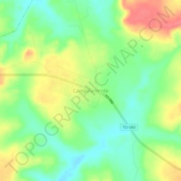
Navn: Topografisk kort Campina Verde, højde, terræn.
Gennemsnitshøjde: 271 m
Minimum højde: 242 m
Maksimal højde: 309 m
Giv en donation
Gør dig klar til dit næste eventyr:
Som Amazon-partner tjener denne side en kommission på kvalificerede køb uden ekstra omkostninger for dig.
Andre topografiske kort
Klik på et kort for at se dets topografi, dets højde og dets terræn.
Gurupi
Gurupi, Tocantins is a city and a municipality in the Brazilian state of Tocantins. The estimated population was 87,545 inhabitants in 2020, the third-largest in the state, and the total area of the municipality was 1,836 km2. The elevation is around 287 meters in the city.
Gennemsnitshøjde: 280 m
Palmas
Palmas is one of the hottest capital cities in Brazil. During the May to September dry season, Palmas can be oppressively hot as temperatures climb into the high 30s (°C). During the October to April rainy season, it is not as hot. The heavy rains and cloud cover keep it much cooler. Palmas receives generous…
Gennemsnitshøjde: 367 m
Giv en donation
Gør dig klar til dit næste eventyr:
Som Amazon-partner tjener denne side en kommission på kvalificerede køb uden ekstra omkostninger for dig.
Palmas
Palmas is one of the hottest capital cities in Brazil. During the May to September dry season, Palmas can be oppressively hot as temperatures climb into the high 30s (°C). During the October to April rainy season, it is not as hot. The heavy rains and cloud cover keep it much cooler. Palmas receives generous…
Gennemsnitshøjde: 367 m
Palmas
Palmas is located at the state's geographic centre at an average altitude of 230 m (755 ft). The city is located between the Serra do Lajeado hills on the east and the Tocantins River on the west. Palmas has a metropolitan area with 471,639 inhabitants.
Gennemsnitshøjde: 367 m
Giv en donation
Gør dig klar til dit næste eventyr:
Som Amazon-partner tjener denne side en kommission på kvalificerede køb uden ekstra omkostninger for dig.
Giv en donation
Gør dig klar til dit næste eventyr:
Som Amazon-partner tjener denne side en kommission på kvalificerede køb uden ekstra omkostninger for dig.
Giv en donation
Gør dig klar til dit næste eventyr:
Som Amazon-partner tjener denne side en kommission på kvalificerede køb uden ekstra omkostninger for dig.
Giv en donation
Gør dig klar til dit næste eventyr:
Som Amazon-partner tjener denne side en kommission på kvalificerede køb uden ekstra omkostninger for dig.
Natividade
The estimated population in 2020 was 9,250, the area is 3,240 km². The elevation is 323 m.
Gennemsnitshøjde: 372 m
Giv en donation
Gør dig klar til dit næste eventyr:
Som Amazon-partner tjener denne side en kommission på kvalificerede køb uden ekstra omkostninger for dig.
Giv en donation
Gør dig klar til dit næste eventyr:
Som Amazon-partner tjener denne side en kommission på kvalificerede køb uden ekstra omkostninger for dig.