
Giv en donation
Gør dig klar til dit næste eventyr:
Som Amazon-partner tjener denne side en kommission på kvalificerede køb uden ekstra omkostninger for dig.
Topografisk kort West Liss
Klik på kortet for at se højden.
Giv en donation
Gør dig klar til dit næste eventyr:
Som Amazon-partner tjener denne side en kommission på kvalificerede køb uden ekstra omkostninger for dig.
Om dette kort
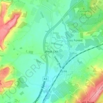
Navn: Topografisk kort West Liss, højde, terræn.
Gennemsnitshøjde: 87 m
Minimum højde: 55 m
Maksimal højde: 164 m
Giv en donation
Gør dig klar til dit næste eventyr:
Som Amazon-partner tjener denne side en kommission på kvalificerede køb uden ekstra omkostninger for dig.
Andre topografiske kort
Klik på et kort for at se dets topografi, dets højde og dets terræn.
Rowlands Castle
United Kingdom > England > Hampshire > East Hampshire > Finchdean
Gennemsnitshøjde: 72 m
Giv en donation
Gør dig klar til dit næste eventyr:
Som Amazon-partner tjener denne side en kommission på kvalificerede køb uden ekstra omkostninger for dig.
Rowland's Copse, Red Hill
United Kingdom > England > Hampshire > East Hampshire > Rowlands Castle
Gennemsnitshøjde: 42 m
Giv en donation
Gør dig klar til dit næste eventyr:
Som Amazon-partner tjener denne side en kommission på kvalificerede køb uden ekstra omkostninger for dig.
Newton Valence
United Kingdom > England > Hampshire > East Hampshire
The village sits high in the westernmost chalk hills of the South Downs: maximum elevation 191 metres (627 feet) above sea level. Much of the surrounding landscape is within the East Hampshire Area of Outstanding Natural Beauty.
Gennemsnitshøjde: 153 m
Giv en donation
Gør dig klar til dit næste eventyr:
Som Amazon-partner tjener denne side en kommission på kvalificerede køb uden ekstra omkostninger for dig.
Bramshott Common
United Kingdom > England > Hampshire > East Hampshire > Bramshott
Gennemsnitshøjde: 148 m
Giv en donation
Gør dig klar til dit næste eventyr:
Som Amazon-partner tjener denne side en kommission på kvalificerede køb uden ekstra omkostninger for dig.
Havant Thicket
United Kingdom > England > Hampshire > East Hampshire > Rowlands Castle
Gennemsnitshøjde: 48 m
Ludshott Common
United Kingdom > England > Hampshire > East Hampshire > Bramshott
Gennemsnitshøjde: 162 m
Farringdon
United Kingdom > England > Hampshire > East Hampshire > Lower Farringdon
Gennemsnitshøjde: 153 m
Giv en donation
Gør dig klar til dit næste eventyr:
Som Amazon-partner tjener denne side en kommission på kvalificerede køb uden ekstra omkostninger for dig.
Ditcham Woods.
United Kingdom > England > Hampshire > East Hampshire > Buriton
Gennemsnitshøjde: 136 m
Giv en donation
Gør dig klar til dit næste eventyr:
Som Amazon-partner tjener denne side en kommission på kvalificerede køb uden ekstra omkostninger for dig.
Shalden
United Kingdom > England > Hampshire > East Hampshire
Shalden is a village and civil parish in the East Hampshire district of Hampshire, England. It is 2.3 miles (3.7 km) northwest of Alton and 1.9 miles (3.1 km) northeast of Bentworth, just off the A339 road. The parish covers an area of 1,536 acres (622 ha) and has an average elevation of 600 feet (180 m) above…
Gennemsnitshøjde: 177 m
Giv en donation
Gør dig klar til dit næste eventyr:
Som Amazon-partner tjener denne side en kommission på kvalificerede køb uden ekstra omkostninger for dig.
Queen Elizabeth Country Park
United Kingdom > England > Hampshire > East Hampshire > Buriton
Gennemsnitshøjde: 151 m
Medstead
United Kingdom > England > Hampshire > East Hampshire
Medstead is a village and civil parish in the East Hampshire district of Hampshire, England. Its nearest town is Alton, which lies 4.3 miles (6.9 km) northeast of the village. According to the 2011 census, the village had a population of 2,036 people. The parish covers an area of 1,536 acres (622 ha) and has…
Gennemsnitshøjde: 186 m
Giv en donation
Gør dig klar til dit næste eventyr:
Som Amazon-partner tjener denne side en kommission på kvalificerede køb uden ekstra omkostninger for dig.
East Tisted
United Kingdom > England > Hampshire > East Hampshire > East Tisted
Gennemsnitshøjde: 171 m
Giv en donation
Gør dig klar til dit næste eventyr:
Som Amazon-partner tjener denne side en kommission på kvalificerede køb uden ekstra omkostninger for dig.
Medstead
United Kingdom > England > Hampshire > East Hampshire
Medstead is a village and civil parish in the East Hampshire district of Hampshire, England. Its nearest town is Alton, which lies 4.3 miles (6.9 km) northeast of the village. According to the 2011 census, the village had a population of 2,036 people. The parish covers an area of 1,536 acres (622 ha) and has…
Gennemsnitshøjde: 186 m
Giv en donation
Gør dig klar til dit næste eventyr:
Som Amazon-partner tjener denne side en kommission på kvalificerede køb uden ekstra omkostninger for dig.
Rowlands Castle
United Kingdom > England > Hampshire > East Hampshire > Finchdean
Gennemsnitshøjde: 72 m
Giv en donation
Gør dig klar til dit næste eventyr:
Som Amazon-partner tjener denne side en kommission på kvalificerede køb uden ekstra omkostninger for dig.