
Topografisk kort Throop
Klik på kortet for at se højden.
Om dette kort
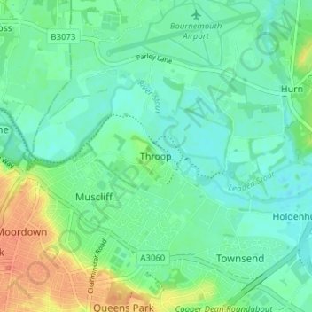
Navn: Topografisk kort Throop, højde, terræn.
Gennemsnitshøjde: 13 m
Minimum højde: 1 m
Maksimal højde: 40 m
Andre topografiske kort
Klik på et kort for at se dets topografi, dets højde og dets terræn.
Christchurch
United Kingdom > England > Bournemouth, Christchurch and Poole > Hurn
Gennemsnitshøjde: 18 m
East Parley Common
United Kingdom > England > Bournemouth, Christchurch and Poole > Hurn
Gennemsnitshøjde: 13 m
Upton Heath Nature Reserve
United Kingdom > England > Bournemouth, Christchurch and Poole > Poole
Gennemsnitshøjde: 40 m
Redhill Park
United Kingdom > England > Bournemouth, Christchurch and Poole > Bournemouth > Talbot Village
Gennemsnitshøjde: 33 m
Hamworthy Park
United Kingdom > England > Bournemouth, Christchurch and Poole > Poole
Gennemsnitshøjde: 2 m
Kings Park
United Kingdom > England > Bournemouth, Christchurch and Poole > Bournemouth
Gennemsnitshøjde: 31 m
Christchurch
United Kingdom > England > Bournemouth, Christchurch and Poole > Christchurch
Gennemsnitshøjde: 8 m
Christchurch
United Kingdom > England > Bournemouth, Christchurch and Poole > Christchurch
Gennemsnitshøjde: 18 m
Christchurch
United Kingdom > England > Bournemouth, Christchurch and Poole > Hurn
Gennemsnitshøjde: 18 m
Island in the Stour
United Kingdom > England > Bournemouth, Christchurch and Poole > Poole > Merley
Gennemsnitshøjde: 28 m
Christchurch
United Kingdom > England > Bournemouth, Christchurch and Poole > Hurn
Gennemsnitshøjde: 18 m