
Topografisk kort Golitha Falls
Klik på kortet for at se højden.
Om dette kort
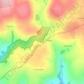
Navn: Topografisk kort Golitha Falls, højde, terræn.
Sted: Golitha Falls, Cornwall, England, PL14 6RU, United Kingdom (50.48924 -4.50293 50.48934 -4.50283)
Gennemsnitshøjde: 200 m
Minimum højde: 101 m
Maksimal højde: 280 m
Andre topografiske kort
Klik på et kort for at se dets topografi, dets højde og dets terræn.
St. Columb Major
United Kingdom > England > Cornwall
St Columb occupies a plateau at about 300 feet (91 m) elevation. The north part of the town (known as 'Bridge') descends into the Vale of Lanherne, having a minimum elevation of approximately 165 feet (50 m). It was originally a linear settlement built on the main road running north-east to south-west, but…
Gennemsnitshøjde: 110 m