
Giv en donation
Gør dig klar til dit næste eventyr:
Som Amazon-partner tjener denne side en kommission på kvalificerede køb uden ekstra omkostninger for dig.
Topografisk kort Tartar
Klik på kortet for at se højden.
Giv en donation
Gør dig klar til dit næste eventyr:
Som Amazon-partner tjener denne side en kommission på kvalificerede køb uden ekstra omkostninger for dig.
Om dette kort
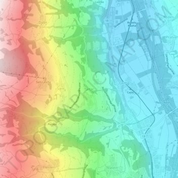
Navn: Topografisk kort Tartar, højde, terræn.
Sted: Tartar, Cazis, Viamala, Grisons, 7422, Switzerland (46.69982 9.39923 46.73982 9.43923)
Gennemsnitshøjde: 984 m
Minimum højde: 635 m
Maksimal højde: 1.646 m
Giv en donation
Gør dig klar til dit næste eventyr:
Som Amazon-partner tjener denne side en kommission på kvalificerede køb uden ekstra omkostninger for dig.
Andre topografiske kort
Klik på et kort for at se dets topografi, dets højde og dets terræn.
Lohn (GR)
Switzerland > Grisons > Viamala > Muntogna da Schons > Donat
Before 2017, the former municipality was located in the Schams sub-district, of the Hinterrhein district, after 2017 it was part of the Viamala Region. It is a haufendorf (an irregular, unplanned and quite closely packed village, built around a central square) located at an elevation of 1,582 m (5,190 ft) on…
Gennemsnitshøjde: 1.594 m
Giv en donation
Gør dig klar til dit næste eventyr:
Som Amazon-partner tjener denne side en kommission på kvalificerede køb uden ekstra omkostninger for dig.
Mathon
Switzerland > Grisons > Viamala > Muntogna da Schons
Before 2017, the former municipality was located in the Schams sub-district, of the Hinterrhein district, after 2017 it was part of the Viamala Region. The village is a haufendorf (an irregular, unplanned and quite closely packed village, built around a central square) at an elevation of 1,521 m (4,990 ft) in…
Gennemsnitshøjde: 1.994 m
Giv en donation
Gør dig klar til dit næste eventyr:
Som Amazon-partner tjener denne side en kommission på kvalificerede køb uden ekstra omkostninger for dig.
Avers
Switzerland > Grisons > Viamala
Avers (Romansh: Avras; Walser: Òòver(s), pronounced [ɔːfər], [ɔːfərs]) is a high Alpine valley region and a municipality in the Viamala Region in the Swiss canton of Graubünden. It includes Juf, the highest-altitude year-round settlement in Europe.
Gennemsnitshøjde: 2.407 m