
Giv en donation
Gør dig klar til dit næste eventyr:
Som Amazon-partner tjener denne side en kommission på kvalificerede køb uden ekstra omkostninger for dig.
Topografisk kort Monte Rosa Massif
Klik på kortet for at se højden.
Giv en donation
Gør dig klar til dit næste eventyr:
Som Amazon-partner tjener denne side en kommission på kvalificerede køb uden ekstra omkostninger for dig.
Monte Rosa Massif
The group is on the watershed between the Rhône and Po basins and has a topographic prominence of 2,165 metres (7,103 ft) which is ranked fifth in the Alps.
Giv en donation
Gør dig klar til dit næste eventyr:
Som Amazon-partner tjener denne side en kommission på kvalificerede køb uden ekstra omkostninger for dig.
Om dette kort
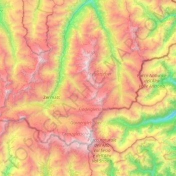
Navn: Topografisk kort Monte Rosa Massif, højde, terræn.
Sted: Monte Rosa Massif, Visp, Wallis, Switzerland (45.85101 7.68498 46.23086 7.98208)
Gennemsnitshøjde: 2.498 m
Minimum højde: 619 m
Maksimal højde: 4.585 m
Giv en donation
Gør dig klar til dit næste eventyr:
Som Amazon-partner tjener denne side en kommission på kvalificerede køb uden ekstra omkostninger for dig.
Andre topografiske kort
Klik på et kort for at se dets topografi, dets højde og dets terræn.
Furi
Switzerland > Wallis > Visp > Zermatt
Furi is an alpine hamlet in the Pennine Alps, located three kilometers south of Zermatt, Switzerland at an altitude of 1,687m. It is located on a relatively flat area of land between the Gornera and Zmuttbach rivers.
Gennemsnitshøjde: 2.206 m
Giv en donation
Gør dig klar til dit næste eventyr:
Som Amazon-partner tjener denne side en kommission på kvalificerede køb uden ekstra omkostninger for dig.
Monte Rosa
Switzerland > Wallis > Visp > Zermatt
The peak is distinguished by the name Dufourspitze (in German, lit. Dufour Peak; French: Pointe Dufour, Italian: Punta Dufour). This replaced the former name Höchste Spitze (English: Highest Peak) that was indicated on the Swiss maps before the Federal Council, on January 28, 1863, decided to rename the…
Gennemsnitshøjde: 4.033 m
Giv en donation
Gør dig klar til dit næste eventyr:
Som Amazon-partner tjener denne side en kommission på kvalificerede køb uden ekstra omkostninger for dig.
Giv en donation
Gør dig klar til dit næste eventyr:
Som Amazon-partner tjener denne side en kommission på kvalificerede køb uden ekstra omkostninger for dig.