
Topografisk kort Setul
Klik på kortet for at se højden.
Om dette kort
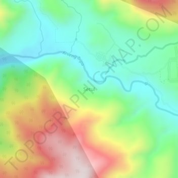
Navn: Topografisk kort Setul, højde, terræn.
Sted: Setul, Tripe Jaya, Gayo Lues, Aceh, Sumatra, Indonesia (4.13485 96.95522 4.17485 96.99522)
Gennemsnitshøjde: 810 m
Minimum højde: 540 m
Maksimal højde: 1.236 m
Andre topografiske kort
Klik på et kort for at se dets topografi, dets højde og dets terræn.
Blangkejeren
Blangkejeren is located in the upper reaches of the Tripa River Basin, at an elevation of approximately 920 metres above sea level. It is a highland town nestled in the Bukit Barisan mountain range of Sumatra.
Gennemsnitshøjde: 1.403 m