Geolocate

Topografisk kort Swallownest

Klik på kortet for at se højden.

👉 Easily get elevation data in JSON, GeoTIFF and KML formats using Elevation API
Tak fordi du støtter denne side ❤️
Giv en donation

Gør dig klar til dit næste eventyr:

Som Amazon-partner tjener denne side en kommission på kvalificerede køb uden ekstra omkostninger for dig.

Om dette kort

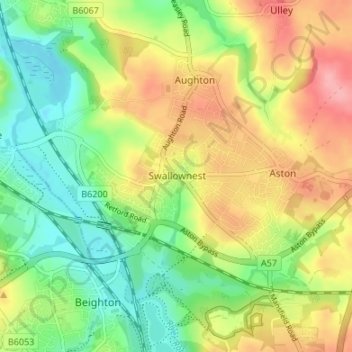
Navn: Topografisk kort Swallownest, højde, terræn.

Sted: Swallownest, Rotherham, South Yorkshire, England, S26 4TZ, United Kingdom (53.34313 -1.34148 53.38313 -1.30148)

Gennemsnitshøjde: 72 m

Minimum højde: 28 m

Maksimal højde: 127 m

Andre topografiske kort

Klik på et kort for at se dets topografi, dets højde og dets terræn.

Wickersley

United Kingdom > England > Rotherham

Gennemsnitshøjde: 116 m

Thrybergh

United Kingdom > England > Rotherham

Gennemsnitshøjde: 48 m

Thurcroft

United Kingdom > England > Rotherham

Gennemsnitshøjde: 111 m

Ulley

United Kingdom > England > Rotherham

Gennemsnitshøjde: 92 m

Hellaby

United Kingdom > England > Rotherham

With a Dutch impression that was influenced by the style common in the colonies, the Hall was built on a hill and hence an extra storey was required to obtain the height at the front elevation.

Gennemsnitshøjde: 113 m

Walkworth Wood

United Kingdom > England > Rotherham

Gennemsnitshøjde: 99 m

Thorpe Salvin

United Kingdom > England > Rotherham

Thorpe Salvin is a village and a civil parish in the Metropolitan Borough of Rotherham in South Yorkshire, England, on the border with Nottinghamshire. It lies between Worksop and Harthill, and is located at an elevation of around 110 metres above sea level. At the 2011 Census, it had a population of 476, down…

Gennemsnitshøjde: 102 m

Firbeck

United Kingdom > England > Rotherham

Gennemsnitshøjde: 62 m

Wentworth

United Kingdom > England > Rotherham

Gennemsnitshøjde: 96 m

Woodsetts

United Kingdom > England > Rotherham

Woodsetts is a village and civil parish in the Metropolitan Borough of Rotherham in South Yorkshire, England, on the border with Nottinghamshire. It lies between the towns of Dinnington and Worksop at an elevation of around 60 metres above sea level, and has a population of 1,746 at the 2011 Census. The…

Gennemsnitshøjde: 70 m

Waverley

United Kingdom > England > Rotherham

Gennemsnitshøjde: 58 m

Orgreave

United Kingdom > England > Rotherham

Gennemsnitshøjde: 57 m

Bramley

United Kingdom > England > Rotherham

Gennemsnitshøjde: 122 m

Ravenfield

United Kingdom > England > Rotherham

Gennemsnitshøjde: 86 m

Dalton

United Kingdom > England > Rotherham > Dalton Magna

Gennemsnitshøjde: 100 m

Todwick

United Kingdom > England > Rotherham > Todwick

Gennemsnitshøjde: 105 m

Brampton Bierlow

United Kingdom > England > Rotherham > Brampton

Gennemsnitshøjde: 55 m

Gør dig klar til dit næste eventyr:

😴Sovepose til 3 sæsoner - Holder dig varm fra forår til efterår i det danske klima
🧤Udendørs handsker - Beskyttende handsker til trekking og køligt vejr
🔪Lommekniv - Alsidigt værktøj til madlavning og småopgaver i lejren
📡GPS‑enhed til outdoor - Håndholdt GPS med topografisk kortsupport
Termos & kop - Holder drikke varme på turen

Som Amazon-partner tjener denne side en kommission på kvalificerede køb uden ekstra omkostninger for dig.