
Giv en donation
Gør dig klar til dit næste eventyr:
Som Amazon-partner tjener denne side en kommission på kvalificerede køb uden ekstra omkostninger for dig.
Topografisk kort Amsteg
Klik på kortet for at se højden.
Giv en donation
Gør dig klar til dit næste eventyr:
Som Amazon-partner tjener denne side en kommission på kvalificerede køb uden ekstra omkostninger for dig.
Om dette kort
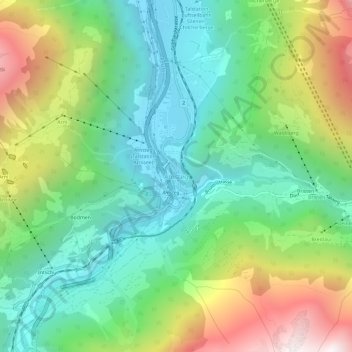
Navn: Topografisk kort Amsteg, højde, terræn.
Sted: Amsteg, Silenen, Uri, 6474, Switzerland (46.75108 8.65033 46.79108 8.69033)
Gennemsnitshøjde: 1.051 m
Minimum højde: 491 m
Maksimal højde: 2.133 m
Giv en donation
Gør dig klar til dit næste eventyr:
Som Amazon-partner tjener denne side en kommission på kvalificerede køb uden ekstra omkostninger for dig.
Andre topografiske kort
Klik på et kort for at se dets topografi, dets højde og dets terræn.
Andermatt
Switzerland > Uri > Korporation Ursern
Andermatt (Romansh: Ursera) is a mountain village and municipality in the canton of Uri in Switzerland. At an elevation of 1,437 meters (4,715 ft) above sea level, Andermatt is located at the center of the Saint-Gotthard Massif and the historical center cross of north-south and east-west traverses of…
Gennemsnitshøjde: 2.127 m
Giv en donation
Gør dig klar til dit næste eventyr:
Som Amazon-partner tjener denne side en kommission på kvalificerede køb uden ekstra omkostninger for dig.
Giv en donation
Gør dig klar til dit næste eventyr:
Som Amazon-partner tjener denne side en kommission på kvalificerede køb uden ekstra omkostninger for dig.
Giv en donation
Gør dig klar til dit næste eventyr:
Som Amazon-partner tjener denne side en kommission på kvalificerede køb uden ekstra omkostninger for dig.
Altdorf (UR)
The municipality covers an area of 10.21 square kilometres (3.94 sq mi). The town proper sits at an altitude of 458 metres (1,503 ft) above sea level on a flat alluvial plain between the right bank of the river Reuss and the steep hillside of the Rossstock 2.4 km (1.5 mi) to the east. The scattered hamlets and…
Gennemsnitshøjde: 796 m