
Topografisk kort Whitwell
Klik på kortet for at se højden.
Om dette kort
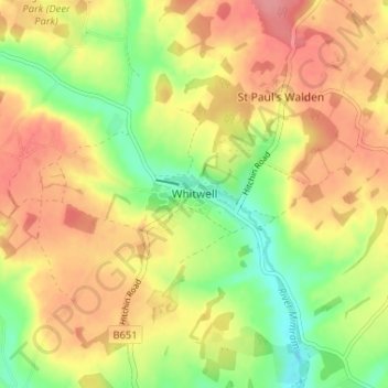
Navn: Topografisk kort Whitwell, højde, terræn.
Gennemsnitshøjde: 122 m
Minimum højde: 79 m
Maksimal højde: 158 m
Andre topografiske kort
Klik på et kort for at se dets topografi, dets højde og dets terræn.
Knebworth Country Park
United Kingdom > England > Hertfordshire > North Hertfordshire > Knebworth
Gennemsnitshøjde: 116 m
Newnham
United Kingdom > England > Hertfordshire > North Hertfordshire > Baldock
Gennemsnitshøjde: 69 m
Windmill Hill
United Kingdom > England > Hertfordshire > North Hertfordshire > Hitchin
Gennemsnitshøjde: 74 m
St Paul's Walden
United Kingdom > England > Hertfordshire > North Hertfordshire
Gennemsnitshøjde: 121 m
Ickleford
United Kingdom > England > Hertfordshire > North Hertfordshire > Hitchin
Gennemsnitshøjde: 58 m
Ivel Springs Local Nature Reserve
United Kingdom > England > Hertfordshire > North Hertfordshire > Baldock
Gennemsnitshøjde: 72 m
Long Pond
United Kingdom > England > Hertfordshire > North Hertfordshire > Offley > Offley Hoo
Gennemsnitshøjde: 142 m
Knebworth Country Park
United Kingdom > England > Hertfordshire > North Hertfordshire > Knebworth
Gennemsnitshøjde: 116 m