
Topografisk kort Lower Nazeing
Klik på kortet for at se højden.
Om dette kort
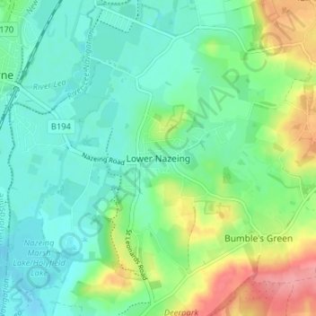
Navn: Topografisk kort Lower Nazeing, højde, terræn.
Gennemsnitshøjde: 43 m
Minimum højde: 17 m
Maksimal højde: 102 m
Andre topografiske kort
Klik på et kort for at se dets topografi, dets højde og dets terræn.
Connaught Water
United Kingdom > England > Essex > Epping Forest > Sewardstonebury
Gennemsnitshøjde: 57 m
Roughtalley's Wood (South) & Epping Forest Woodland Burial Ground
United Kingdom > England > Essex > Epping Forest > Coopersale
Gennemsnitshøjde: 96 m
Epping Forest
United Kingdom > England > Essex > Epping Forest > Debden Green
It lies on a ridge between the valleys of the rivers Lea and Roding. It contains areas of woodland, grassland, heath, streams, bogs and ponds, and its elevation and thin gravelly soil (the result of glaciation) historically made it less suitable for agriculture. The Forest was historically managed as a common;…
Gennemsnitshøjde: 44 m
Stanford Rivers
United Kingdom > England > Essex > Epping Forest > Stanford Rivers
Gennemsnitshøjde: 65 m
Epping Forest
United Kingdom > England > Essex > Epping Forest > Debden Green
It lies on a ridge between the valleys of the rivers Lea and Roding. It contains areas of woodland, grassland, heath, streams, bogs, and ponds, and its elevation and thin gravelly soil (the result of glaciation) historically made it less suitable for agriculture. The forest was historically managed as a…
Gennemsnitshøjde: 44 m
Epping Forest
United Kingdom > England > Essex > Epping Forest
It lies on a ridge between the valleys of the rivers Lea and Roding. It contains areas of woodland, grassland, heath, streams, bogs, and ponds, and its elevation and thin gravelly soil (the result of glaciation) historically made it less suitable for agriculture. The forest was historically managed as a…
Gennemsnitshøjde: 44 m