
Topografisk kort Fiskerton
Klik på kortet for at se højden.
Om dette kort
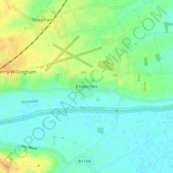
Navn: Topografisk kort Fiskerton, højde, terræn.
Gennemsnitshøjde: 10 m
Minimum højde: -1 m
Maksimal højde: 29 m
Andre topografiske kort
Klik på et kort for at se dets topografi, dets højde og dets terræn.
Welton CP
United Kingdom > England > Lincolnshire > West Lindsey
The parish stretches from the ancient Ermine Street (A15) in the west, following a north-easterly shape to the Barlings Eau at its eastern end, of which the Welton Beck is a tributary, and is an example of a strip parish. Due to the low, flat topography of Lincolnshire, land had to be drained for agriculture…
Gennemsnitshøjde: 27 m
Rase Park
United Kingdom > England > Lincolnshire > West Lindsey > Market Rasen
Gennemsnitshøjde: 28 m
North Willingham CP
United Kingdom > England > Lincolnshire > West Lindsey > North Willingham CP
Gennemsnitshøjde: 82 m
Corringham CP
United Kingdom > England > Lincolnshire > West Lindsey > Corringham CP
Gennemsnitshøjde: 21 m