
Topografisk kort South Harting
Klik på kortet for at se højden.
Om dette kort
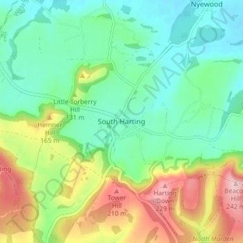
Navn: Topografisk kort South Harting, højde, terræn.
Gennemsnitshøjde: 109 m
Minimum højde: 43 m
Maksimal højde: 238 m
Andre topografiske kort
Klik på et kort for at se dets topografi, dets højde og dets terræn.
Selsey
United Kingdom > England > West Sussex > Chichester
A study published by Princeton University and McGill University, in 2020, concluded that the Manhood Peninsula is at particularly high risk of flooding as its topography is less than 5 metres (16 ft) above the current mean sea level and that by 2100 Selsey will be subject to permanent inundation.
Gennemsnitshøjde: 1 m
West Wittering
United Kingdom > England > West Sussex > Chichester > West Wittering
Gennemsnitshøjde: 2 m
Harting
United Kingdom > England > West Sussex > Chichester > South Harting
Because of its elevation Beacon Hill, just to the east of Harting Down, hosted a station in the shutter telegraph chain, from 1796 to 1816, which connected the Admiralty in London to its naval ships in Portsmouth and Plymouth. This was replaced in 1822 by a semaphore station which operated on a slightly…
Gennemsnitshøjde: 101 m
Donnington Park
United Kingdom > England > West Sussex > Chichester > Donnington
Gennemsnitshøjde: 8 m
Upwaltham
United Kingdom > England > West Sussex > Chichester
The Skytrain was from the 27th Transport Group. On 11 February 1945 it was on a flight from Paris–Le Bourget Airport to RAF Grove in Berkshire. It crossed the Sussex coast about 1125 hrs at an altitude of only 300 to 400 feet (91 to 122 m). The weather was worsening, visibility had decreased to 25 yards (23…
Gennemsnitshøjde: 152 m
Barlavington
United Kingdom > England > West Sussex > Chichester > Barlavington
Gennemsnitshøjde: 50 m
Horncroft Common Plantation
United Kingdom > England > West Sussex > Chichester
Gennemsnitshøjde: 22 m
Selsey
United Kingdom > England > West Sussex > Chichester
A study published by Princeton University and McGill University, in 2020, concluded that the Manhood Peninsula is at particularly high risk of flooding as its topography is less than 5 metres (16 ft) above the current mean sea level and that by 2100 Selsey will be subject to permanent inundation.
Gennemsnitshøjde: 1 m
Upwaltham
United Kingdom > England > West Sussex > Chichester
The Skytrain was from the 27th Transport Group. On 11 February 1945 it was on a flight from Paris–Le Bourget Airport to RAF Grove in Berkshire. It crossed the Sussex coast about 1125 hrs at an altitude of only 300 to 400 feet (91 to 122 m). The weather was worsening, visibility had decreased to 25 yards (23…
Gennemsnitshøjde: 152 m
Selsey
United Kingdom > England > West Sussex > Chichester
A study published by Princeton University and McGill University, in 2020, concluded that the Manhood Peninsula is at particularly high risk of flooding as its topography is less than 5 metres (16 ft) above the current mean sea level and that by 2100 Selsey will be subject to permanent inundation.
Gennemsnitshøjde: 1 m