
Topografisk kort Star
Klik på kortet for at se højden.
Om dette kort
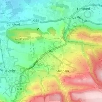
Navn: Topografisk kort Star, højde, terræn.
Sted: Star, Somerset, England, BS25 1QB, United Kingdom (51.30148 -2.82596 51.34148 -2.78596)
Gennemsnitshøjde: 101 m
Minimum højde: 8 m
Maksimal højde: 260 m
Andre topografiske kort
Klik på et kort for at se dets topografi, dets højde og dets terræn.
Mells Park
United Kingdom > England > Somerset > Vobster
The architect Edwin Lutyens had known the Horners, and Mells Park, since 1896. In 1918 he unsuccessfully tried to persuade the Horners to rebuild Park House. However, Reginald McKenna, the chairman of Midland Bank, and formerly Home Secretary and Chancellor of the Exchequer under Asquith, was married to Pamela…
Gennemsnitshøjde: 134 m
Muchelney
United Kingdom > England > Somerset
Muchelney (/ˈmʌtʃəlni/) is a clustered village and civil parish in Somerset, England, extending for 3 kilometres (1.9 mi) from the south bank of the River Parrett and that has a clustered centre. This is 1 mile (1.6 km) south of Huish and Langport and 4 miles (6.4 km) south west of Somerton in the South…
Gennemsnitshøjde: 9 m
Glastonbury Tor
United Kingdom > England > Somerset > Glastonbury
The Tor is in the middle of the Summerland Meadows, part of the Somerset Levels, rising to an elevation of 518 feet (158 m). The plain is reclaimed fen above which the Tor is clearly visible for miles around. It has been described as an island, but actually sits at the western end of a peninsula washed on…
Gennemsnitshøjde: 33 m
Quantock Hills National Landscape
United Kingdom > England > Somerset > Over Stowey
Gennemsnitshøjde: 116 m
Priddy
United Kingdom > England > Somerset
The village lies in a small hollow near the summit of the Mendip range of hills, at an elevation of nearly 1,000 feet (300 m) above sea-level, and has evidence of occupation since neolithic times. There are remains of lead mining activities and caves in the limestone beneath the village.
Gennemsnitshøjde: 206 m